Always to the frontier
Showing posts with label Arizona. Show all posts

Sunday, April 19, 2015

The Place Of Desert

For the last year or so in American Voyages, I have been largely focused on eastern North America.  My long-time readers and those who dig further into the heap of posts will find that my emphasis started out in a completely different direction, that of the vast, diverse wild-lands that is the West (or in the case of Mexico, the North).  My travels out there were what ultimately inspired me to give a go at this blog, but heaven knows I did not start out loving such a place.  I grew up in the boreal forest, which remains to me the most primal, holy, and majestic landscape on the planet.  I viewed the southern pinelands as the next most incredible landscape, followed by a child's imaginary view of the evergreen forests of the western rainy reaches, and largely disliked that which was in between, the world of the deciduous forests and grasslands.  When it came time for me to take my first ground trip across the continent, I was dreading the flat, boring plains that I would be forced to endure.

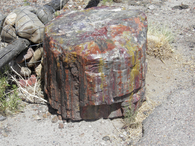
Of course my image of them was made uglier by what I figured they would be, a continuation of the flat, artificial cornfield "prairies" of far southern Ontario, Ohio, and southern Michigan.  There was no life between the Appalachians and the Rockies, I had gathered.  But then I drove into central Illinois and saw the sky get bigger.  I crossed the Mississippi and found Iowa to be rolling, and in places where the farms had gone fallow, lush green lands dotted with the occasional Bur Oak (Quercus Macrocarpa) standing as a lone witness to another world.  August rains had come and blessed the land so that it looked as if it were something out of Hobbit country.  Again, I placed my conception of the world on top of the landscape as it truly existed and was perhaps even eager to be seen by my overly-focused eyes. 

Then came Nebraska, and some more corn, especially between Lincoln and where the Platte and I-80 meet for the first time heading west.  That river though, that shallow, silty, seemingly unimpressive river... it stole my heart and my attention.  Perhaps it was the trees that did this; tough-as-nails Cottonwoods (Populus Deltoides) forming gallery forests that made the trip so much more enjoyable for my stubborn sylvan-centric tourist agenda.  The funny thing is, though, my eyes started looking for the prairie.  I had long wondered what the transition between eastern forest and western void was like, and found instead that the corn, or at least my concern for it, had prevented me from finding this remarkable transition area.  Around North Platte, however, I saw it; hills of grass and what I presumed was only grass.  I-80 kept following the rivers, but I was headed for golden California, and the majestic mountains of Colorado.  I turned onto I-76 and into the High Plains, and much like viewing a religious icon, my mind was made quiet and my gaze indirect.  The immensity of all that was not human overtook my concentration; not for nothing have many religious experiences of some of the most intense contemplative types from western Christianity (Jesus, in fact, started to "find himself" in the desert) to the Lakota mystics who once ranged far and wide over that same northeastern Colorado grass included sharing that nature made them forget the self and connect with the infinite.

Doubtless I found such a place in the small, innocent world of childhood.  I remember the towering pines and ancient granite of the Canadian Shield transporting me far away from the worries of the present.  Then I grew up, indulged in material culture, formed a rigid world view like most other college students sharply liberal and conservative alike tend to do, and forgot about my and my world-view's insignificant place in the cosmos.  At some point I started realizing that this was at best silly and at worst insulting to myself, my place in history, and my purpose in the greater world.  Maybe I was looking for something else, or something more whole... but that trip to California plunged me into less of a tourist run and into more of a pilgrimage.  The High Plains cleared my mind and prepared me for the grandeur of the mountains to come, and more surprisingly so, the desert beyond.  I was amazed at the vista given by the Front Range, but the High Plains managed to keep me even more enthralled with my first ever glimpse of an honest-to-goodness western plant, the Sand Sagebrush (Aretmisia Filifolia).

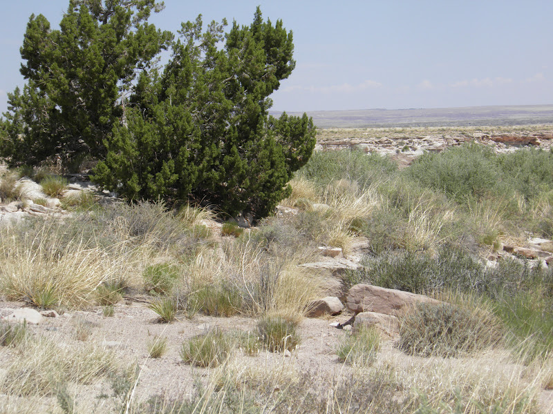
This one was taken at Pipe Spring National Monument, on the other side of its range compared to where we first met on the Colorado High Plains.  I think this is where we fell in love. 

If you've never experience one, I would say that it alone is an excellent reason to go out west.  It feels and smells incredible, with the best olfactory performance coming after a rain.  Like so many White people before me, I always viewed sagebrush as an afterthought, even a weed.  I had encountered its northernmost version, Artemisia Frigida, back in my magical boreal youth.  Perhaps I was bred to hate prairie, however, because I found nothing likeable in that patch of meadow that constituted the "back yard" where I found my first specimen of this plant.  I have since apologized to what I assume is its children.  Back then, however, I was all about the pines, like so many people are.  No one can tolerate the fly-over states, and they seem to view anything even drier as either a wasteland, the backdrop for Vegas and sci-fi movies, or a good place to extract resources and produce more crap for us to throw away.  I certainly headed into my California voyage with a similar attitude.  Then I saw the open skies, and then I saw the sagebrush, and then I saw the yuccas... and then the cacti.  Nearly two years later, on a misty March day, I saw the saguaros, and a view of the desert that had gone from hard on life that had turned into otherworldly had then become something closer to ethereal.  The desert is a place teeming with life that has managed to not only make the best of the situation, but in many cases to positively thrive there. 

I write this because far too often we dismiss the desert as an unwelcome, useless intrusion into our idealized view of the world.  We like it lush and green, happy and managed/cultivated.  Our vision of the world, even the wild portions of it, are often frowned upon if they do not conform to our place in it.  This attitude exists in persons as different as lobbyists for the Koch brothers or ecological restorers concerned with the dwindling wolf populations on Isle Royale.  Those religious types I mentioned would probably tell the rest of us to focus instead on greater things than our immediacy.  I write this because today I read a piece related to this post, written by an "activist" living in the Mojave, an atheist no less.  I wanted to share his piece here, with all of you, and give a brief description of my own of why I think it is important.  Please, take the time to read it, because I'm shutting up now.

https://www.beaconreader.com/chris-clarke/the-desert-is-not-your-blank-canvas

Thursday, February 14, 2013

Northern Forests of Arizona

OK, so by now most of my readers get that when I state something will be in the next post, I really mean the next post when it is convenient.  I wanted to take the week to share with the world just how great Detroit is and can be, and only got a little past the theoretical stage of that discussion.  The fact of the matter is that I do not have a lot of photographs of the area, despite having lived here a decent amount of time so far.  I suppose this condition is something similar to New Yorkers never going to see the Statue of Liberty, or more so, New Yorkers never taking pictures of their city.  Thus, I think I will spread out the Detroit love throughout the blog whenever I come across some interesting things to share.

To continue on with the blog in general...

This year, being the Auroral Maximum, when the Northern Lights will be more spectacular than ever, American Voyages will be dedicated to all things northern.  That's right, anything that has more spruce than people will be featured in this glorious year of 2013, even if northern falls far to the south.

Take a look at the misty forests on the north rim of the Grand Canyon:


That's right, this place is all the way down in Arizona, land of sunshine, giant cacti, and vast desert stretches.  As you can see, there is nary a cactus around, and the place is quite wet.  Elevation can extend Le Nord quite some distance south, well into Mexico.  While the trees might be a little more Western Mountain than James Bay, the overall effect is the same.  


Friday, January 11, 2013

105 Years Ago

On this day, the Grand Canyon became permanently protected.


Both shots are from the north rim, which is an absolutely beautiful way to experience the canyon.

We might think that no one could want to harm this vista and land, but the truth of the matter is that hordes of miners were eyeing the exposed geology with riches in mind beyond the dreams of avarice.  Later on, even as a park, the thing was almost flooded for dams!  We have since come to recognize the greater value of this and many other wild lands.  Still, if people fought over something so obviously scenic and powerful, you can imagine how the struggle continues to protect lands (including just plain old water sources) that hold no apparent immediate value.

Thursday, December 20, 2012

Saguaros!

This picture, a lovely gift from a friend in Utah, was too good to not pass along here.

No clue where this is from, other than somewhere near Phoenix, Arizona.

Here we have a nice northwestern Sonoran Desert scene, complete with Saguaro cacti (Carnegiea Gigantea) and Green Paloverdes (Parkinsonia Microphylla), along with some blurry other cacti and shrubs.  Saguaros tend to be found in the wetter portions of the Sonoran Desert, where they can establish easily in the double feature winter and summer rains.  They are also a bit cold sensitive, being killed if freezing temperatures persist more than 30 hours or so.  This largely accounts for their distribution in Arizona and Sonora.  Paloverdes are also interesting species, having bark which can act as leaves do and photosynthesize for the plant.  They actually lose their leaves (which are not really big anyway) in summer and grow them back in the wetter winter and spring.

Though the scene above does not look very alive at the moment, in a few months it will be rejuvenated by winter rains and wonderful sunny spring days.  The ground will be green with grasses, flowers will carpet the land as far as the eye can see, and the place will look like an exotic paradise.  Perhaps the best feature of a place like this is the smell, especially right after a rain.  It's so indescribable that you really have to go there and experience it to understand how this might be one of the best smelling places on the planet.

Oh, and nothing is cooler than Saguaros.  They just look awesome.

Sunday, December 9, 2012

Taking the Alternate Route

"Thanks to the Interstate Highway System, one can now travel across the country from coast to coast without actually seeing anything."  -Charles Kuralt

How right this man was.  Express highways have transformed not only our travel experiences, but an entire culture.  I had been meaning to write about the concept for some time, especially after I had an experience this summer of seeing the Toronto-North Bay corridor in Ontario pretty much reduced to a rapid transit pathway.  Where before there had been delightful little towns with great roadside restaurants and maple sugar candy shops, 2012 had shown itself to be the year of excessively mowed down forests (to make room for hundreds of yards of clearance on either side of the glorious new double-landed divided highway) and signs that point off an exit toward towns that now exist to travelers only in name.  This, of course, is old news back in the United States, where the transition from interesting federal highways to streamlined interstate took place more than half a century ago.  There, little towns faded out of existence in some cases, along with grand urban cores that diminished as people could now more easily live in distant suburbs and commute further away from, in less time (the brake lights say otherwise), downtown areas.

Fortunately, nostalgia and tourism can often combine in an effective marriage.

In Springfield, Illinois.

US Highway 66, now largely supplanted by I-55, 44, 40, and 15, is one such child of this nuptial blessing, and rightly so the most famous of buried highways.  When the interstates replaced her long, glorious road from Lake Michigan to the Pacific Ocean, many roadside attractions, businesses, and entire communities suffered greatly.  Still, many have survived, enough so that taking the business loop on the modern freeways is definitely a worthwhile experience, if for no other reason than to see the namesake of song lyrics.

Yes, you really can stand on the corner in Winslow, Arizona, but you have to exit I-40 in order to do so.

Tourist traps and affordable hotels aside, heading down the older highways is often the only way to get to travel some of the former great travel paths of the continent.  Much of the emigrant trails of the 19th century have not been replaced by modern interstates, where technological advances in engineering allowed for more direct routes to be carved and blasted through formerly difficult terrain.  Those wishing to get to California or Oregon the more traditional way need to say goodbye to I-80 at Ogallala, Nebraska.  Sure, you don't get to speed along in your car at 80mph or more, but a solid 60 is not horrible, and you can pass by things like, well, this:

Chimney Rock, at Bayard, Nebraska.  US 26 can take you there!

You know, just as people used to, because it was an easier, more pleasant route, and because you could actually see a thing or two on your way out there.  Sometimes the first part does not always hold true, as is the case with US-6 going over, rather than tunneling under, the continental divide, but the second part usually benefits from this.  I doubt I will ever want to drive I-15 in Utah again, not after the fun and dangerous route I got to drive on Utah 2.  The views alone were worth the extra gas.  That said, I actually think I used less gas, because I was not driving like a rabid dog barreling down the interstate.  Something can be said for the old 55mph limit.

Friday, August 10, 2012

The Arizona Snowbelt and Volcanoes of Flagstaff

Like much of the rest of the continent, Arizona is a land of extremes.  While most people figure the land to be a sun-baked desert favored by golfing retirees, 27% of the state is still forested, which is actually on par with many countries in western Europe.  One such area makes up a good portion of the middle of the state, in a lovely mass of pines that stretch from the rim of the Grand Canyon to the New Mexican border, surrounded on the north and east sides by high sagebrush desert and grasslands, and on the south and west sides by the desert of imagination, the Sonoran, complete with the branching saguaros and seemingly bare mountains.  The lands on the north and east sides looking into the mountains and forests can be seen in an earlier post here.  Of course, the crowning point of the coniferous oasis would be the volcanic peaks around Flagstaff, renowned for their quality of skiing and picturesque proportions.

The San Francisco Peaks from I-40 eastbound, about 7 miles west of the peaks and Flagstaff, and 7200 feet above sea level.

When a child draws a picture of a mountain, usually a triangle with a jagged snowline and cap on top, these peaks are just about what they look like, owing to the neat (if volatile) formation of volcanic mountains such as these.  The scene is enough to make one think they are in some part of California or Colorado rather than dusty hot Arizona, but this is where that picture was taken, not 20 miles from the northern edge of the Sonoran desert.  Elevation means a lot out here, so much so that traveling from Phoenix to Flagstaff (150 miles) is the climactic equivalent of traveling from Phoenix to Montana or Alberta.  The area around the base of the peaks can often reach into the mild 40's during the day, but the freezing nights in the teens and persistent snowfall of 100 inches a year usually means a nice powder of several feet blesses the landscape for some time.  These were the exact conditions when I was last there, in the third week of December back in 2008.  "Powder" certainly described the snow, which gets its light consistency from being depleted of saturation after Pacific rains hit the California coastal mountains, their leftover moisture is spread thin in the desert skies, and then are forced against these higher elevations once more, this time very much, well, powdery.  This is surely one of the more difficult places in the world to make a wet and powerful snowball.

About 10 more miles back from the vantage point in the photograph above.  The peaks are visible from as far away as Williams.  

This sort of landscape survives in pockets even further south into the Sonoran desert in the form of "sky islands", mountains that catch leftover Pacific moisture before it makes a powerful stop in the Rockies to the east.  The great central Arizonan forests do reach a southern end generally north of I-10 and the Mexican border, where they are separated, by a bridge between the Sonoran and Chihuahuan deserts consisting of lovely grasslands and oak woodlands, from ranges to the south that carry the alpine forests and winter snows well south into central Mexico.  Like much of the rest of the arid west, the snows and forests are quickly passed through on our present modes of transportation, which no doubt leads to an even greater impression on passersby.

Saturday, July 7, 2012

Our Most Widespread and Adaptable Plants

When we think of hardy plant life that can be found almost anywhere, we tend to think of things like grasses, willows, junipers, and even some of our native oaks which can be found everywhere from swamps to bone dry parts of the Arizona mountains.  While these plants do tend to be widespread, they are also quite specific in their needs and do not thrive or even survive in habitats that they are unaccustomed to.  Granted, things like the short grasses of the high plains and the various oaks got the way they are through adaptation, but it was less of an evolution and more of a taking advantage of conditions that other plants could simply not compete with them over.  They are indeed survivors, and without them, North America would have a lot more desert-like wasteland about.  

But what about those deserts, where only the strongest plants, animals, and even people seem to make life happen?  They are hardly as barren as they seem, especially in the higher reaches where just a little bit more rain falls to make the difference between true aridity and a thriving community of nature that takes what it can get from slim pickings in resources of water.  The shrubs and other plants there either look far down into the earth for water (most mesquites have taproots that extend 60 feet or more into the ground) or have widespread roots that suck up as much of the wet stuff as they can when rain does finally come.  Again, though, these are plants that have become accustomed to certain conditions.  One would be hard pressed to find some of these plants in the tropical parts of Mexico or in the frosty boreal forest.  

There is one family of plants that does just this, however.  They are the cacti, and they are pretty ubiquitous plants:

Yes, I forgot to fill in the Caribbean islands, and they grow there too.  Let's keep this to the mainland I suppose.
North America, more than any other continent of the world, is a dry place.  Sure, we have small areas such as the Pacific Northwest that are usually drenched, but even there, drought is never guaranteed to stay away.  Some of our most severe drought to date can be found in the normally humid and rainy Georgia and Alabama.  Despite having a reputation as a gloomy city, Seattle actually gets as much rain as New York City in an average year of precipitation, and some fine days may boast sunsets unencumbered by even a single cloud in the sky.  On top of this, we also tend to get extremes in temperature that, while not considered normal occurrences, do not exactly come as a shock either.  Again, we have plants that can take all sorts of conditions, but are usually only found in some parts of the continent, such as the prairie flowers which are becoming very popular in gardens as water bills continue to rise.  Cacti, on the other hand, can be found in habitats ranging from the boreal forest to the tropical parts of Mexico.  They can be found near the treeline in the Sierra Nevadas, or growing between the rocks at the edge of the salt flats in Death Valley.  All but one species, in fact, are native to the Americas, with the highest diversity being concentrated in northern and central Mexico (which is also the center of diversity for pines).

They are true survivors and have evolved in a remarkably short period of time.  No fossils of cacti have ever been found, but their restricted natural distribution to the New World suggests that they developed from other plants sometime after the Americas became isolated from the rest of the world landmasses, which means they could have developed anytime during the past 130 million years.  In comparison, pines (another very widespread and adaptable type of plant) have been with us possibly as much as 290 million years ago, and trees in general are thought to have developed into recognizable forms (if not species) as early as 100 million years before that.  Cacti started out with leaves, but diverged from other plants by growing spines that would soon replace the leaves, the function of which would be taken over by the very skin of the plant itself. The only remaining survivor of this original form is known today as the Rose Cacti (Pereskia Grandiflora):

The stem of the Rose Cactus, courtesy of R.A. Howard @ USDA-NRCS PLANTS Database
The Rose Cactus is native to northeastern Brazil, which is actually a fairly wet place.  Some drier parts of the region exist, but for the most part the sky dumps about 40-70 inches of rain a year on the ground.  At the same time, the soil is not the best that Brazil has to offer, being a sandy affair that often drains and dries quite quickly.  (I was looking for reasons to go to out of the way parts of Brazil one day, and seeing one of these in habitat for myself might just do the trick.  Brazil also happens to be the world center for genetic diversity in palms!)  What sort of a plant would thrive in conditions where water was available, but not necessarily all of the time?  This sort of plant, with a stem that turned from something that still resembles wood into something that could also store quite a bit of water.  As part of its transition from a woody plant into something a bit more succulent and softer, it grew spines to protect and also shade itself.  It retains its leaves for photosynthesis, as its skin is still largely a woody business, and apparently has dazzling flowers.  What happened to its off-shoots then?  They kept the spines, ditched the leaves in favor of a nice green (but not always) body, and definitely kept the flowers.  

Arizona Barrel Cactus (Ferocactus Wislizeni), taken during a very memorable misty day in Saguaro National Park, Arizona.  
Cacti flowers, in fact, can be among the most brilliant and noticeable blooms of any wildflowers.  My favorite that I have thus encountered (and lost the pictures for, sadly) would have to be the Beavertail Cactus (Opuntia Basilaris).

Brother Alfred Brousseau @ USDA-NRCS PLANTS Database
They add real vitality to a desert scene when most of the spring wildflowers have already started to succumb to the higher temperatures and onset of summer dryness.  Cacti definitely do tend to complete a desert scene, and a popular conception of the American southwest often has a butte framed by a sunset with a Saguaro (like the one in the background of our blog) raising its arms to the sky.  They tend to stand out even more, however, in places where they are least expected, such as in a sandy patch of ground in a forest in Michigan, a beach on Long Island with a backdrop of New York City contrasting with it, or even growing in mossy cracks in the granite of the Canadian Shield in northern Ontario!  I can tell you from personal experience that they look very, very exotic in these settings, but not entirely out of place either, sort of like finding a Royal Palm in the Everglades or a lone towering pine at the edge of its range growing into the prairies.

That's right, we have a kind of plant that you really can find just about anywhere, one that ties our continent together in a botanical celebration of taking advantage of the weird water conditions our great land throws at us.  This tough little fellow is the Fragile Prickly Pear (Opuntia Fragilis), and it keeps getting found in places where most other plants beyond moss or lichens would just plain give up.  

Taken by Daiv Freeman in Minnesota, copyright 2010.  Daiv has a wonderful website on all things cacti, which can be found at cactiguide.com.  
It has been found (and I highly recommend checking out this article) in Michigan's upper peninsula:


Fragiles have also been found in Manitoba and right across the border around Lake of the Woods in Ontario, and appear quite happy to grow in the otherwise botanically restrictive Canadian Shield rock.  Recent finds have occurred in Kaladar, Ontario and surrounding areas.  They like granite.  They like well-drained soils (like sand).  One figures they might be a bit more common than we think.  Apparently they were one of the first plants to chase the melting glaciers at the end of the last ice age!  Cacti are nothing of short of amazing, and a wonderful part of our natural heritage throughout the continent.  On top of this, they taste great, and look amazing in a garden.  Our native people certainly thought so.

Monday, June 18, 2012

The Dramatic Virgin River Gorge

One of the more interesting stretches of main travel corridors in North America is Interstate 15.  I-15 starts its north-south journey at the United States-Canada border in Montana, where it follows the base of the Rockies before heading south into the mountains.  Eventually, it passes through the Great Basin alongside the Wasatch Range of Utah and through the Mormon-founded cities of Salt Lake, Provo, Cedar City, and St. George, at which point it descends into the Mojave Desert.  For the most part, I-15, like many other limited access highways, was engineered to provide for a relatively level driving experience that would eliminate both the speed-reductions inherent in climbing elevations by switchbacks and grades over 5% and also the engineering costs associated with such road design.  For the traveler seeking a much more dramatic and scenic route, the Federal highways and local roads are definitely the way to go.  This is not to say that the scenery is by any means boring.  As noted, I-15 passes through a complete column of North American landscapes, from grasslands to mountains to deserts and finally into the unique landscapes of southern California between Victorville, California and San Diego.  What it does mean is that the experience is a bit more manicured and serene rather than totally wild.

There are exceptions, of course.  Despite the best intentions of planners and engineers, the rugged western North American landscape eventually puts up a challenge even to modern convenience.  On such place is a short trip of less than 30 miles in extreme northwestern Arizona.  Separating the small portion of the Mojave that surrounds St. George, Utah is an abrupt rise of elevation on nearly all sides.  A few small tributaries of the Colorado River, and a larger one, the Virgin River, manage to cut through the western mountains of these surrounding peaks, often quite dramatically.  The canyons these water courses create form the only real passes into the rest of the Mojave beyond, and the builders of I-15 had no choice but the follow the impressive cut that the Virgin had made, at least without blasting and tunneling through a lot of land.  Even then, the work was expensive, and the drive would end up being nothing short of spectacular.  

At a few points the sky disappears and one is surrounded by huge walls of rock, which owing to its Mojave location, are quite devoid of much in the way of vegetation other than sagebrush, creosote, various cacti, and Joshua trees.  While the descent into St. George from the Great Basin to the north is the true entrance to the Mojave for I-15, this would be the first look inside the door into a grand entrance hall down a spiral staircase.  The best part is, such a view through I-15 is only scratching the surface, as the second and higher floors above the canyon walls rise further into truly lovely lands of a marriage between desert and forests.  I have only caught glimpses of this elevated world from the majesty below, but I was fortunate enough to come across a fellow blogger who knows the area quite well.  His post can be found here.

Anyway, with as dramatic a drive as this is, one imagines it would keep unfolding into far more dramatic territory than the edge of the comparatively mundane Great Basin that the driver has left behind to the north.  Well, it turns out that the Mojave shares the topographical characteristics of its cooler northern neighbor, which features large basins among high ranges.  Not a mile after exiting the canyon, one comes across deceptively flat expanses of desert.  I say deception is in order, because towering peaks loom once again around the flats for pretty much the rest of the trip through the desert.  Nevertheless, it is quite a contrast!

 The wild nature of the landscape also gets tamed at this point, and as one crosses the state line into Nevada, the seemingly ordinary town of Mesquite is encountered, complete with multi-lane roads and strip malls.  This being Nevada, they also have casinos and other unique diversions.  Americana, it seems, is never far away from an interstate highway, even deep in the wild west.

Friday, March 30, 2012

Volcanoes in Arizona

O'Leary Peak is a volcano within a field of volcanoes in central Arizona, around Flagstaff.

The San Francisco Volcanic Field, which O'Leary Peak is but one summit of, is largely dormant, but by no means extinct.  Almost all types of volcano can be found here, from the violent stratovolcanoes to the ash spewing pyroclastic cones.  O'Leary Peak is a lava dome, which is generally quite peaceful, but now and then can build up enough pressure to explode, as did Mount Saint Helens.  8,500 foot O'Leary Peak is one of the larger volcanoes in the area, but is still dwarfed by the San Francisco Peaks.

The Peaks can be seen from as far away as the north rim of the Grand Canyon and the Petrified Forest, both well over 100 miles away.  The 11,000 foot peaks are snow packed in the winter, with nice, light powder that makes for excellent ski country.  Surrounding the volcanoes is high desert, which all in all, makes for a delightful contrast of lava, snowfields, pine forests, and desert.  The ancestral Puebloan people delighted in the variety of the land, and many fine ruins, some very much intact, can be found in the immediate environs.

Friday, February 17, 2012

Petrified Forest National Park

In 1906 the Antiquities act was passed by the United States Congress and signed into law by who we can only  imagine was a rather giddy American president Theodore Roosevelt.  Section 2 of the act permitted the president to set aside parcels of land deemed worthy of preservation, which caused quite a stir at the time (and still receives a bit of bad mouthing today, but thankfully bi-partisan efforts to back up executive decisions regarding the act usually quiet things down).  The forth monument proclamation set aside a stretch of desert on the Colorado Plateau that had piles of petrified wood everywhere.  Petrified wood was no secret treasure; nearly every state and most nations of the world have some variety of wood that has petrified by various means.  Here, however, the wood was plentiful, whole logs remained intact, and looked far more beautiful than many other varieties that had been known at the time.

The problem, of course, was that people could not resist taking souvenirs.  Commercial ventures and organized greed followed innocent rock hunting, and much of it had been hauled away a mere 40 years after Lt. Amiel Whipple surveyed the land and reported about the wood.  Roosevelt was certainly ready to preserve what was left of the wood, and certainly knew about the scenic beauty of the surrounding land.  Congressman John F. Lacey (credit is due to The Wilderness Warrior by Douglas Brinkley) was apparently instrumental in getting Roosevelt to actually sign off on the deal, even while he was also working on preserving Crater Lake and Jewel Cave.  Lacey considered the Petrified Forest to be one of the most amazing treasures of the entire continent.  The Arizona territorial legislature apparently agreed with him, as they had been pushing for protection of the land since 1895.  The monument was created in December of 1906, and later re-designated a full national park in 1958.  Theft of the wood continues to this day, but it was greatly slowed down.  

So what is so special about this place that it deserves national park status?  Well, the wood itself is certainly gorgeous, but it also sits in the Painted desert, which I have to say, certainly lives up to the name, especially at sunset.  One of the reasons that color photography was first developed was to show people how beautiful this land truly is.  The truth is that pictures, as is the case for so many wonders of the natural world, can barely do the place justice.  Seeing this land with one's own eyes is definitely recommended, although the sensory experience does not stop there.  Much of the North American deserts have such unique smells, sounds, and even just a plain feel of the air to them, and this particular portion is no exception.  The air quality, in fact, is considered by the National Park Service to be among the highest of anywhere in U.S. territory.  Anyway, what does the Painted desert look like?


It looks like it was painted.  Much of the area is part of the huge Chinle Formation, which extends throughout much of the southwest and can be found prominently featured in Zion, Capitol Reef, and many other fine places.  

What else is here?


The Puerco pueblo, along with some associated petroglyphs, and even older markings dating back as many as 2,000 years ago.  

While the land seems a bit inhospitable, the climate was apparently pretty decent in the past if such a settlement was founded here.  The Puerco river, while mostly a dry wash, does have some amount of water in it underground, as evidenced by the Cottonwoods.  


Far more recently, people have been using the area as a passing point.  The attraction of the wood, and the convenient location off of Route 66, now Interstate 40, has meant that a lot of tourists have come by this way.  Route 66 enthusiasts consider this park and surrounding area to be one of the main highlights of the classic trip down the length of the mother road, and the old road bed can be seen here, alongside the Painted Desert Inn, which has been lovingly restored.  


Aside from all this, of course, there is the wood itself.  While not exactly a "forest" in the conventional sense of the term, points of interest such as the Rainbow Forest certainly have nice collections of the stuff, including large logs.   


Apparently, before dissolved silica managed to turn wood into, well, almost quartz, some of these trees used to be redwoods.  Such a wet climate must have seemed like a different world compared to the high desert of the Colorado plateau which exists at the present.  Again, however, the desert has its charms, and this particular one, being over 5,000 feet up (the level land and presence of a rain shadow prevents much growth in the way of junipers of pinyon pines), does not have the scorching 100's of the lower deserts to the south and west.  While the main attraction is definitely the wood, ruins, and painted landscape, this is probably one of the better places to explore the "fifth American desert" of the Colorado plateau.  Here one can find lots of sagebrush, various smaller cacti and yuccas, as well as cottonwoods (and the disgusting, invasive, evil Tamarisks) along the Puerco river.  There is even a chance to see the odd White-tailed antelope squirrel and  a lizard or two.  
 This had to be my favorite cactus I have seen in a while.  It had a lot of character for being such a small thing.


Now, as far as the wood goes, while it is illegal to collect any within the park, and huge amounts of it have been scoured from surrounding areas, there are numerous shops that can legally sell you souvenirs of wood harvested from outside the protected area.  I would recommend Jim Gray's Petrified Wood co., which has an incredibly large shop that also sells other Arizona mineral specimens, and has fashioned logs for sale.  Believe it or not, the chair was pretty comfortable.  The eastern stretch of I-40 in Arizona has a bunch of other shops as well, but some might be a bit less reputable in collecting sources.  Even at Jim's, I was not immediately comfortable with the ethics of the situation, though when I spoke to the staff, I changed my mind.  They truly do care about the land, and were surprisingly far more polite and knowledgeable about it than the (non-ranger) staff at the actual park.

All in all, a pleasant place to visit.  Due to the open nature of the terrain, and the distance from any point sources of light pollution, this would be a great place to do some wilderness excursions and back-country camping.  There are supposedly more logs out there, waiting to be discovered.