Always to the frontier

Tuesday, April 23, 2013

Our Great Ancient Highways: The Ottawa River (Natural History)

The Ottawa River is a no-contest winner for being the most important river in Canadian history.  From its beginnings as a great glacial drain to its current predicament as a border between Quebec and Ontario, this river has served as a conduit for quite a lot of energy, both natural and human.

While are not exactly sure how old the Ottawa River is, we do know that it sits within a 175 million year old rift, the Ottawa-Bonnechere Graben.  The rift lies within much older rock, the Grenville Province of the Canadian Shield.  While some parts of the Shield include the oldest surface rock on the planet, dating back to four billion years ago, the Grenville portion, which includes the Laurentian and Adirondack Mountains, is actually much younger, at a "mere" 1-2 billion years of age.  The edges of the rift are pretty easy to come across, namely on the southern edge, which forms rises of elevation nearly 1,000 feet in height along the middle Petawawa River, one of the largest tributaries of the Ottawa...

The tallest portion of the southern edge of the rift can be found alongside Cedar Lake in Ontario.  The peaks of the range are nearly 1,000 feet above some of the surrounding lower elevations.  At this latitude, what would account for only minor changes further south becomes an interesting collection of transitions within the boreal world.  The ridge also causes a slight rain shadow and alters weather patterns on Cedar Lake, a very turbulent body of water for its size.

As well as the northern edge, which can be seen all along the Ottawa River, particularly in the Gatineau Hills north of Ottawa, and the peaks of the Laurentians across from Mattawa and Deep River, Ontario...

The Ottawa River in a more or less natural state at the confluence of the Ottawa and Mattawa Rivers.  The opposite shore is the north fault wall of the rift.

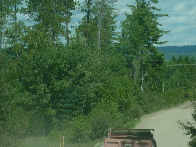
The Brent road, near  Deux-Rivières, Ontario, looking north.  The ridge in the background is the north edge of the Ottawa Valley.  Seen here are typical pine forests of the lower elevations of the valley.  White (Pinus Strobus), Red (Pinus Resinosa), and Jack (Pinus Banksiana) Pines thrive in the incredible masses of sand which are found here.  The pines formed the backbone of the early Canadian logging industry.
Going forward to about 10,000 years ago, give or take a few thousand years, the Laurentide Ice Sheet was melting.  As she gave up her immense volume of water, she first found outlets in the ancient Mississippi River system, and then in the primordial Great Lakes, where she also left much of her aquatic bounty.  Eventually though, the warmer world defeated her persistence in a conflict that continues to this day between the Gulf of Mexico and Hudson Bay, a conflict which gives eastern and central North America some of the most regularly dramatic weather on the planet.   Her last major drain before emptying back onto herself and into far more northerly realms was the Ottawa River system.  Where once a continental glacier had emptied its meltwaters into the vast drainages further south, it was now forcing itself into a comparatively minor river system.  One can only imagine what that much water, "a thousand Niagaras", would have been like gushing through the Ottawa, Petawawa, Barron, and Bonnechere Rivers.  So much water emptied out here that the Atlantic Ocean briefly stretched inward as far as Pembroke, Ontario in an arm called the Champlain Sea.  We can only imagine...

We do know one consequence though.  The ice sheet left us sand.  A LOT of sand.


The best sand on earth, in your author's opinion, and he has taken in some fine sand in the tropics and deserts.  I even wrote a post about it.  The Ottawa Valley is full of it, especially from Mattawa and downstream, as well as along its major rivers named above.  Even down past Ottawa where the river gets a bit more broad and even slightly "southern" looking, in parts even refusing to expose its granite underbelly, there is sand to be found.  This sand, in fact, supports some of the easternmost natural prairie in North America.  The pines like it, the birches and aspens tolerate it, but nothing can handle large, flat, hot stretches of sand like grasses and friends of grasses.  Well, I suppose the pines like it as much as the grasses.

The Brent road, one of the many wilderness roads that one can take to easily explore the dense pine lands.  


That's pretty much what is underneath the Ottawa, and what it flows through.  Sand and lots of Canadian Shield stuff, mostly granites, gneisses, and even gabbros.  Down between Ottawa and its mouth near Montreal one runs into some limestone, but for the most part this is a Shield River through and through.  The water is as black as tea in many reaches, a gift of the dense forests and bogs that feed it, very much different from many of the silt laden rivers that drain the rest of the continent.  Like them, however, the river is very wide for much of its length.  The Ottawa passes through a variety of landscapes as a result, including the boreal forest, the transitional forests, pine barrens and remnant prairies, urban and rural areas, and some desolate looking sand spits and beaches that remind the explorer that even with all this water around, we tend to remain a somewhat drier continent.  For the most part, a trip up or down the Ottawa is a trip in the north country, with a few tastes of the rest of the northeastern continent.

Over her short 790 miles, the Ottawa only descends about 1,100 feet, (a descent over a comparatively steeper gradient than the Mississippi's, albeit of equal elevation) but she used to have some pretty intense rapids in places until they were dammed over in the last half century or so.  As such, the Ottawa was never really an ocean-accessible river like the Mississippi or Colorado were, at least not for larger vessels beyond canoes or logging rafts.  For the canoes and rafts, though, it was a very, very attractive road indeed, which we will explore in the next post.

Monday, April 22, 2013

Happy Earth Day (And National Parks Week)!

I promised at least a picture of a great North American river last post, and I just had to post something on Earth Day, so here we are, the Ottawa River, great gateway to the west for generations upon generations of Canadians.  This is just past where it connects to the Mattawa River, which further connects the St. Lawrence downstream with the Upper Great Lakes by way of Lake Nippissing and the French River.  The valley is probably among the most scenic parts of Ontario.  Next post we can get a bit more in depth perhaps.


Wednesday, April 17, 2013

A River Runs Through It

People from the United States and Canada just do not walk enough.  Even going one step up, we largely abandon bicycles by the time we can drive cars, or we reserve them for pleasure activities or such.  Some would say that our increased mobility and commute times are the natural progression for a cultural development that tries to include as much of the world as possible in plain sight.  We have, after all, access to an information that network that can tell us almost anything about the globe within minutes if not sooner.  Yet for as connected as we seem to be, so many of us here know so little about how people from even the other side of town live.  We form images that correlate to our political and social expectations for other people, and we dismiss other countries and regions outright just because they are different from us.  Then again, perhaps we are not so xenophobic as we are indifferent and self-centered.  We can, after all, get almost anything we need right down the block at a supermarket or even just online.

In doing so, we lose a lot of perspective.

Not so the people of thousands of years of time until recently, not so of our ancestors.  While we envision some "Indian" sitting by a creek being at one with nature with a bow in his hands, we tend to think of him as primitive and unaware of a wider world around him.  While we envision some rough and ready frontier settling Kentuckian or Ontarien splitting wood outside his one room log home, we think of him as little better, just some backwoods guy with little on his mind other than digging a root cellar.  The reality for both sorts of person, however, was quite different.  

Before the second born even came close to having regular contact with the world across the ocean, the first born were busy traveling thousands of miles up and down the vast waterway networks which honeycomb the continent.  

The Clarion River in Pennsylvania as seen from I-80 westbound looking north.  


Trades were made across vast stretches of land, polar bear furs in some cases being exchanged for shells from the Gulf of Mexico (and a bit more than that, for sure).  People in Mexico knew about the colder lands of mountain and plains to their north, as people in the Ohio valley knew about Moose hunters far to the north of them.  As much as peaceful exchanges happened between such distant peoples, conflicts also approached this sort of grand scale.  The Haudenosaunee (Iroquois), attempting to wipe out the Wendat (Hurons) chased their victims from the north shores of Lake Ontario clear to the north shores of Lake Superior, only to instead run into the Ojibwe (oh come on, you know it's Ojibway) who then fought the combined forces of most of the Six Nations back to the Alleghenies only to focus their own attention then back all the way over to Wisconsin and drive the Lakota clear out onto the plains of western Nebraska and eastern Wyoming!  

When more capitalistic minded Virginians, Quebecois, Mexicans, and such figured out that North America, while vast, was also something good to explore, settle, exploit, and marvel at, they took every page they could out of the native handbook to continental mobility and wanted to see just what was on that western horizon.  Of course, they did so the same we do, albeit with a twist: they took the highway.  The highway, of course, was the river.  

As you can see from the picture above, our rivers are just plain big even thousands of miles inland.  Sure, we have rapids and waterfalls that rival anything else in the world, but we also big wonderful waterways that can take one more than 1500 miles into the continent from their mouths at the ocean without causing too many difficulties in terms of travel hazards.  Our rivers can even help travelers cross deserts in relative safety, a feature which really helped to open up northern Mexican expansion and get people to California from out east without passing out in a thirsty mess.  We had overland routes too; they were simply indispensable shortcuts, but until the coming of the railroad, they could be difficult runs and even a bit frightening.  People usually did embark on grand journeys across the land on foot, but they often did so on a path beside the waters which they knew would lead them to a more pleasant destination, and maybe even end up as the destination itself.  

Next Post: One such river.  Let's take a look at our neck of the woods as a town on a road rather than just a town and maybe see what sort of perspective people without (yes, I know, ironic) internet would have.

Wednesday, April 10, 2013

A Priest Among The Temple Of The Secular

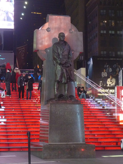
Continuing with some off the beaten path New York coverage, we come to Time's Square.  A little bit on the beaten path, you might say?  Maybe if one focuses entirely on the neon signs, huge advertisements, people lining up in restaurants and shops to spend, spend, spend...  But among the noise and glitter, right in front of everything and everyone stands a statue of a Roman Catholic priest, Father Francis P. Duffy.


Like your author, he was born in Canada, moved to the United States to live there, and responded to a divine call to become a priest in the Roman Church.

He felt very passionately about his adopted homeland and served as a military chaplain for her.  He proved himself every bit as much the leader on the battlefield that he was in a parish or seminary and was regarded highly in this respect by his Irish-American regiment.  Back home in New York he was among the most influential speakers in the public sphere to convince the country that Irish-Americans and other Catholic Americans could be and indeed were patriots and in love with their country, a rather uphill battle for anyone to fight until well into the 20th century.

Times Square, like so much of New York, has been paved over and illuminated to attract tourists, commerce, and perhaps help the city get rid of the memory of its difficult rise to global prominence.  The prosperity and immensity of today's New York, however, has been built on a foundation of racial and cultural conflict, environmental destruction, and the illumination of history.  The arduous and often bloody struggle to help define American liberty and purpose saw New York burned and turned into a pit of people against people in segregated bastions of neighborhoods.  Men and women like Father Duffy were there as American consciousness awakened here in the heart of her historical imagination and memory.

He is honored by a statue that no one looks at (not a single person took even a passing glance in the ten minutes that I stood near it just to see if anyone cared) in the northern part of a square that bears his name.  In some ways we are like a Rome of Late Antiquity, too concerned about the politics of the moment to pay any attention to the statues in our forums that record our past, even while we continue to build more monuments to the glory of our people.

If ever you find yourself among some great wonder of the human world, do not be afraid to question where the foundation lies for what you stand upon and have come to appreciate!

Monday, April 8, 2013

Manhattan Before Manhattan: Ontario in New York? A Rocky Question.

Most images of Manhattan focus on its world class skyline and numerous commercial and cultural attractions.  Broader shots of the island as a whole, usually taken from the Empire State Building, show a rather rectangular flat island crowded over in all but Central Park.  In reality, however, the New York area, even Manhattan island, is an incredibly beautiful natural landscape featuring everything from mountains and forests to prairies and lovely beaches.  Before the urban core of New York was paved over it featured a very attractive paradise which lured both First and Second Born alike to her shores.  Most of her natural features have long since been transformed; even where nature seems to persist (such as in Central Park) the world has been carefully groomed and altered to human tastes.  Some protected areas, such as Fire Island, contain remnants of what the early Dutch colonists found here.  Pine barrens persist in central Long Island, and the New Jersey Meadowlands have so far still largely eluded development.

Most enduring of all, however, would be the geological features of the area.  While human development has generally preferred flat spaces for urban growth, the fact remains that the rocky Earth still manages to defy modern engineering when using its own weapon of economics against itself.  A cliff is too expensive to level, and large outcrops of granite, gabbro, and other fun ancient stuff is just too much of a pain in the ass to constantly dynamite.  One of the most impressive features to be seen from the big city, right in it in fact, would be the Palisades, sheer cliffs that confront many westward views across the Hudson River into New Jersey.

The lower deck, westbound, of the George Washington Bridge (I-95) looking toward New Jersey and those majestic Palisades.  You can see views like this from upper Manhattan northwards for some distance, until around the Tappan Zee Bridge.  

Perhaps I have always been focused enough on the natural world to notice the contours of the land and natural features even when surrounded by human grandeur, but one of the first things I noticed when emerging from Penn Station in my first ever trip to New York was the beginnings of those cliffs as I stared all the way down 33rd street and across the Hudson.  I always subconsciously imagined New York as being flat and nothing but buildings, even if my reading had told me otherwise.  When I left the city after that first visit, I took the Empire State line clear back to Buffalo and was able to see the entire length of the tidal Hudson north to Troy, including going underground past what looked remarkably like the rocks of the Canadian Shield so very far to the north.  The great city, riddled with sewer and subway tunnels, was carved into a very rocky heart that looked like it could have been pulled out of northern Ontario or Quebec.

The inspiration for this post, in fact, came from a very Shield looking outcrop that I passed along the Harlem River, not too far opposite from Yankee Stadium.  It even had quartz veins in it!  I could not snap a picture because I was focused on dealing with the insane traffic, but thankfully Google streetview helped me find again what really took me by surprise.

To find this and other outcrops, simply look anywhere along Harlem River Drive or the stretch of I-95 in Manhattan.  

I mean come on, the thing could very well be something one can find in Ontario!  The actual stuff is too young by far to hold a candle to that Shield rock, however.  What you see is probably only 500 million years old, even if it does have schist and gneiss in there, even a little bit of marble.  The ancient Shield can be found relatively close by, 150 miles away in the Adirondacks, a detached part of the Laurentian Mountains.  Billion year old granite, which not part of the geological core of the continent, can be found even closer in the strip of Appalachians which the Hudson forces through in between West Point and Sing Sing Prison.

Forgive the fuzziness, it was dusk.  This is along I-87 southbound, pretty close to where New York's suburbs start.  

That's right, the mountains of the east come within a mere twenty miles of the concrete jungle.  The Appalachian trail passes through here on a pedestrian bridge over I-87, and is among the lowest elevation (and most urban) of stretches of the otherwise wilderness oriented trail.  It can be amusing to think that some tourists are camping out and even sleeping under the stars even as others are posting photos of Time's Square from their mobile devices not a few dozen miles away.  Even in New York we can find ourselves still trying to interact with our wild world which is never truly far away.

Tuesday, April 2, 2013

Thanks!

Last month, despite a paucity of posts, American Voyages hit an all time high viewer count of any month out there.  Apparently you like reading my takes on history and international relations, which probably means I need to write more on the matter.  The purposes of this blog are to share perspectives on the geography and history of our continent, and thus far it seems like that is something I have been doing.  I was debating about shutting down the blog as I do not seem to have much time for it these days, and it does come with a cost; in the absence of any ads or monetizing efforts (and trust me, I would be earning a decent income off of this), the blog costs money to keep up and running.  I keep getting pageviews, however, as well as comments and questions at BKryda@Gmail.com.

That in mind, let's keep up with this thing.  In the spirit of a continuing exploration into the heart of a North American identity, have this shot of heading west on I-80 through the Delaware Water Gap, one of the great breaches in the Appalachian wall that our ancestors used to see just what was beyond yet another western horizon.

The left rise is Pennsylvania, and the shot is taken from New Jersey.