Always to the frontier
Showing posts with label Wildfires. Show all posts

Friday, June 29, 2012

The Eastern Forests and Plant Succession

This was going to be another Q and A, but I ran into this question that deserved an extended response:

Q: It really is hard to imagine prairies existing so far east.  Are you sure that some of them are not just abandoned fields?  I mean I know you explained that we once got a lot of fires and such here, but we also have a lot of rain and water in general, and most land that I have seen go to seed again turns into a forest in a bit of time.  I think you just get excited when you find wildflowers.

A: More of a comment than a question.  Maybe both?  Cuomment?  Prairies and more so savannas existed well into areas that we imagine are only forests.  Central Mississippi and Alabama, both notable for being quite humid and rainy places, once had an extensive band of tallgrass prairie known as the Black Belt.  The pine flats stretching from Long Island to Miami were a mosaic of thicker forests merged with savannas, which southward also include wonderful shrubs in the underbrush like the Dwarf Palmetto (Sabal Minor):

Google Earth Streetview at above coordinates, or just south of Vero Beach, Florida, on I-95, east side, northbound.  

All of these areas were much more prone to regular rainfall than the interior plains, but what they shared in common, indeed, what makes grasslands possible is a combination of moisture, fire, soil, and sun exposure.   In earlier posts about how savannas and eastern grasslands work, I noted that the forest and grass were locked into a never-ending natural battle against one another that depended greatly on the specific combinations of the above ingredients.  In places a bit further off of the front lines, the ingredients would favor one over the other.  The suppression of natural fire regimes from the nineteenth century onward have skewed such patterns, but in other ways have showed us accelerated models of what a transition from a seemingly barren prairie into a lush forest can look like, often in a period of a few decades or even less.  While the above picture is somewhat natural and "ordinary", it is also somewhat indicative of what happens when the ingredients have been altered.  The shrubs are starting to take over far more than they otherwise would, and the forest is, well, turning into a forest rather than a savanna or "pine barrens".

Was the above stretch of land ever a thick forest?  It might have been, and it might be again, which is part of the wonderful process known as plant succession that defines the shifting mosaic of landscapes that is natural eastern North America.  Fortunately, there are ways to advance beyond conjecture to figure out what used to be "open" and what used to be "closed", ways which also do a lovely job illustrating what succession is all about.

First of all, we can check records from those who came before us.  When Europeans landed on these shores, they were often amazed at the world that stretched before them, leaving us journals and other accounts of what they found as they pressed into the interior.  While these days we get excited over things like skyscrapers and deluxe shopping malls, people then noticed things like big trees, rocks, and even landscapes that surprised them, like the "park like lands of pleasant Michigan".  We tend to think of our ancestors as hacking their way through a primeval forest that was untouched by the native folk, when the truth of the matter is that they often had a fascinating voyage of discovery and enjoyed the variation in the landscape.

Secondly, we can take a look at what is actually in patches of land like the above shot.  If this was once a "solid forest", there would be a lot of stumps in the palmettos, either from the passing of lumber men or a raging inferno, the latter of which would have taken out much more of the canopy and left us with a different forest from what we see, namely one with either fewer or no trees, or one far more arboreal, as in here:

Streetview, the special friend takes us to I-95 northbound again, this time just south of Jacksonville, Florida.

Where we do have more of a forest, we can also take notice of isolated elements in the canopy.  Where we do have either a really broad tree or one that stands out from the rest of a dominate stand of just a few species, this can indicate that at one point this area did have ground that was exposed.  Why is this?  Well, a canopy, while not exactly perfectly uniform, does more or less expand up and out at a rate that favors quicker growing species which tend to dominate everything else, such as maples.  Very rarely does an opening stay exposed long enough for a massive oak or pine to out-compete a bunch of sun-struck maples.  A really broad oak, for example, might be a sign that the area was once an oak savanna.

Taken in Island Lake State Recreation Area, Michigan.
A lone trooper like this Eastern Red Cedar (Juniperus Virginiana) almost certainly means that instead of growing so well in the shade of the canopy, the tree is a survivor of something far more exposed.


Taken at Brighton State Recreation Area, Michigan.  Yes, I know it looks like an Eastern Hemlock.
In fact, it would not be too out of place to suggest that the above scene may have once looked like this:

At an edge of Island Lake State Recreation Area, Michigan.  


Now I don't know the history of the site pictured well enough to claim it is an actual grassland, either emerging or remnant, but the soil is rather sandy (the hills around there, in fact, are stabilized dunes).  In any case, Eastern Red Cedar is an opportunist that can really only get started and prosper under sunny conditions, and often pioneers tree cover on abandoned fields.  Here it is a passing feature of changing landscape.  In more greatly open areas, such as parts of Oklahoma, it is native but actually considered a noxious weed!  I have seen some on oak savannas, which have always been a bit of a misnomer to me anyway.  Yes, oaks are resistant to fire and can handle the drier conditions offered by exposure, but so can these things, junipers, and pines.  


Regardless of what tree deserves the crown of the landscape, our isolated friends are but another way of showing us that nature is not as compartmentalized as we suspect her to be, but always in motion.  This is how we can get from this: 


Taken at Island Lake State Recreation Area, Michigan.  Prairie Remnant converging into Oak Savanna.


To this: 


Taken at Brighton State Recreation Area, Michigan.  Prairie Remnant with edges dominated by savanna converging into mature Oak-Hickory forest.


To this: 


Taken at Brighton State Recreation Area, Michigan.  A little bit of everything, but mostly becoming a mature Maple-Beech forest, a half mile from the above photo.

Basically, nature provides new conditions that the flora of the area then move in to take advantage of.  At first, sun-loving plants that can tolerate not only a bake but also some rather dry soil dominate the situation.  They can be maintained by fires even if they only occur once every few years to a decade, as competing shrubs and trees will be burned out.  Sometimes, however, the fires will not come around, animals such as deer will not graze on certain patches of ground during years of abundance, and the soil quality might have been good enough to allow some species to make a rebound quicker than others.  Given the chance, many areas of eastern North America will indeed progress from grassland to savanna to a dry forest to a more moist forest.  Again, it all depends on the ingredients available, how they are used, and how much they are used.  


Nature is not static.  Yes, we have prairies so far east of the drier rain shadow of the Rockies not because we share general climate conditions with the plains states, but because nature has provided opportunities for these ecosystems to flourish, but they are hardly always passing elements of the landscape.  This also means that not everything was a forest before we came by and plowed it all into farms and cities.  The forest, as much as the grassland, was dependent on conditions to make it possible in the first place.  Was there a lot of forest?  Yes.  Was there also enough open and park-like land to be noticeable?  Yes.  Very often we do have areas that have been forest for a very long time, often hundreds of years.  Sometimes we even get lucky enough to see a rather lovely marriage of the different worlds.

Taken at Brighton State Recreation Area, Michigan.  In the middle of a mature Oak-Hickory forest we have a shaft of sunlight penetrating to the forest floor and letting a Black-Eyed Susan (Rudbekia Hurta) grow amidst its much taller friends.

Tuesday, June 26, 2012

North America's Artificial Tropical Land: Southern Florida

With the exception of historical photos, data maps, and otherwise very impressive photographs and videos, I have wanted to display only pictures that I have taken.  This is not so that I may show off my amateur photographic skills, which a professional photographer friend have said are lacking, but so that I may present things from experience and a personal perspective.  Pictures are wonderful things, but as I have stressed so many times before, they don't complete the story.  That said, I have not been to certain parts of the continent in a while, meaning I don't have a lot of pictures around.  At the same time, even a picture backing up descriptions of sensible experiences is still just a description.  Let's face it, the time has come to move around a bit a more here, and so from here on out, I will be making use of images gathered from around the internet (so long as I have some sort of a sensible connection to them).  When they are not my own photographs, I will include their source in every caption.  This will also be a great way to explore "off the beaten path" from more than just the blog.

So, that in mind, let's head to the Florida that exists beyond the tourist hot spots and postcard perfect beaches.  Why?  Because when I was browsing some nature books last night, time and again, I came across a refusal to document anything from southern Florida (and Mexico) because it feels too much like a copy of the Caribbean islands.  If you ask me, I think they were just afraid of the production costs of adding in a bunch of more pages to make their guides exhaustive, but here we are.  Southern Florida is a very unique place on this globe, deserving of far more recognition than to be dismissed as "part of something else".  True, it does have some botanical and animal species that are also found in Cuba, the Bahamas, and southwards, and it also has some species that extend their range slightly into the tropical realm from as far north as Quebec, like the Red Maple (Acer Rubrum).  Raccoons (Procyon Lotor) live alongside American Flamingos (Phoenicopterus Ruber).  More unique and becoming increasingly rare is this scene below:

http://forums.gardenweb.com/forums/load/palms/msg0319222516174.html?28
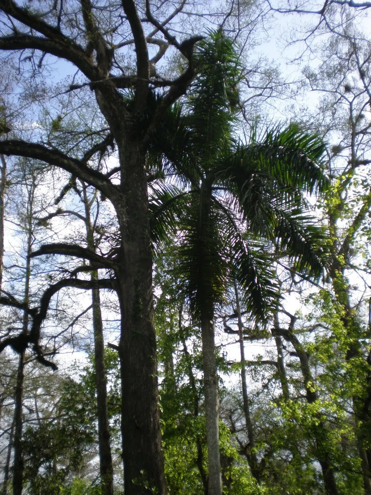
Here we have a wild Florida Royal Palm (Roystonea Regia) growing in a hammock among the Bald Cypress trees, which are noticeably bald during the winter, even though it is commonly in the mid seventies or warmer even in the depth of January.  Deciduous trees do still lose their leaves here, though sometimes the change of brilliant color to bare branches back to spring flowers and leaves only takes a matter of weeks, if even that long.  For the most part, the casual visitor to southern Florida will not even notice this subtle transformation of a pretend winter, as the wild areas that do remain are full of enough broad-leaved evergreens and pines that the northern species do not make much of an impression.  There are native mahogany trees here, as well as the Gumbo-Limbo (Bursera Simaruba), three kinds of mangroves, and 13 native species of palms!

The parts that are not wild, well, they are packed so full of exotics and invasives from the tropics around the world that one would be hard pressed to find something genuinely southern Florida.  This happens to be the case because it is the one place in the United States where tropicals can safely be grown, and in the fine American tradition of planting one's property with perceived beauty over native species, there are manicured lawns everywhere along the suburban streets of Miami and Fort Lauderdale that boast just about every kind of flowering tree and palm you can imagine.   I would know, because when I was growing up, it was the first place and time where I realized that many of the trees around me were not there when things were wild and untamed.  I was six years old and had just taken an interest in both reading in English and noticing that the trees in our Fort Lauderdale backyard were very different from the trees in our Milton, Ontario backyard.  Of course, at that time, even while I wondered what "forest Florida" looked like as opposed to city Florida, I also delighted in the sheer beauty of all the tropical flowers, trees, and even lizards around me, native or not.  I did not care that everything was here artificially and introduced, and especially did not mind that we were even in the actual tropics.


That's right!  Southern Florida does indeed have a tropical climate, but even Key West lies 40 miles north of the Tropic of Cancer.  This is because the land is surrounded by water, and very warm water at that.  This is the birthplace of the Gulf Stream, which also (usually) makes Europe's winters much warmer despite being as far north as much of Canada.  Artificial climates and plants aside though, nothing can really take away from how exotic this land is, both its manicured Miami environs and its primordial but vanishing Everglades wilderness.  The contrast is very noticeable:


Much of the densely, yet comfortably, packed urban areas are built on the only true solid ground in the land, a ridge of limestone which rises only 10 feet or so above the surrounding ocean and everglades, with 24 feet marking the highest point in Coconut Grove, a Miami neighborhood which has retained much of its hammock character of dense mahogany and Gumbo Limbo groves towered over by pines, palms, and the odd high-ground Bald Cypress.  Still, Coconut Grove is but a remnant, and a very incomplete remnant, of what the Miami rocklands once looked like, which was mostly dominated by southern pines.  Development aside, the absence of regular fires in the landscape has altered what remains of the vanished pine rocklands even more. Below is a sample video of some of what remains of this ecosystem and the role of fire in maintaining it, presented by Everglades National Park, which gives you a pretty good idea of what Miami looked like before it was Miami:


This is also a good video for illustrating the role of fires even in a wet and humid place like this.


Outside of the developed areas are vast open prairie-like stretches of sawgrass interspersed with other hammocks; in essence, a very wide, very slow river that drains much of what is green on the map there.  Much more can be said about this unique extra-tropical tropical land, but hopefully this post has served as a nice introduction to one of the extremities of the continent, which we will be revisiting a lot in the future.

Tuesday, June 19, 2012

What is Going on With Wildfires? What is Going on With the Blog?

In the last few months abnormally hot and dry spring weather has given life to an extended wildfire season.  To date, we have seen massive fires in New Jersey, Michigan, California, Colorado, Wyoming, New Mexico, and other areas.  The conservationists tend to point the blame on human-induced climate change, while the developers claim that such fires are the result of over-zealous preservationist schemes which have given us overgrown landscapes and the turning of a blind eye towards residents of such regions.  What is true?  Who is to be believed?  Well, it depends on the situation really.  Take our fires in the Rockies around the Front Range and the Medicine Bow Mountains.  A likely cause of such wild spreading flames would be the vast amounts of fuel that are available to the inferno, but not because of any overgrowth.  The fuel here is dead trees, mostly killed off by the Mountain Pine Beetle (Dendroctonus Ponderosae), and his colleague, the Western Spruce Budworm (Choristoneura Occidentalis).  Both insects are opportunists, going mostly after old, decaying trees, and the younger trees which have yet to develop adequate defenses against their attackers.

This tends to fulfill a nice role in the natural cycle, but only when nature herself is experiencing a proper cycle.  In the past few decades, temperatures have been rising in the region, and a life cycle that was largely restricted to an adult stage in the brief alpine summer of late June through August has now moved up as much as a month or more.  Simply put, the bugs are looking for more to eat, and they are also getting higher up on the slopes that would have been too cold for them to handle.  What gets left behind?


Dead forests that just explode when a fire happens to come into the area.  There have been a lot of big changes to the Rocky Mountain ecosystems lately, and with the High Park Fire being news lately, this has raised a lot of big questions yet again in the political arena.

I had posted on this earlier, in a post on the source of the Colorado River.  I used cautious language then, as I often do in this blog, because I want people from a wide variety of political viewpoints to read what I have to say and discover the raw beauty of our landscape without turning away because of some fear of a radical conservationist viewpoint.  While I do not retract my statement made in that post about the insect issues in Colorado and elsewhere, I will say that what has turned our forests dead has probably been the insects.  You see, this is what is so tricky about this and so many other issues regarding the natural world.  Environmental issues are heavily politicized and the preservationist instinct is so strong that some times conservation efforts also turn into a semi-religion while the opposition points this out and tries to gain the upper hand by decrying such sentimentality.   One of the "religious" issues, of course, is wildfire.

For most people, an image of a forest fire would probably be a bad thing.  Most of us from North America are familiar with Disney films, among them the famous Bambi which featured a scene involving scared animals running from a huge forest fire towards the end of the movie.  I know it scared me to death when I saw it as a child, especially since I was familiar with the lovely forests of northern Ontario in which I grew up.  This and other images in popular culture have stuck with us, and the idea that forest fires are bad have been seared into our consciousness ever since.  Frightening and tragic news images of homes being destroyed have only added to a public fear and distaste of wildfire.  We get upset when a church burns down, and sometimes even more so when the cathedral of nature is torched.  Surely, then, wildfire is an evil to be expunged!  Not quite, but nor is it to be actively embraced.

This sort of thing got wild land management into big trouble throughout North America when it turned out that protection efforts and suppression of fires, regardless of whether they were naturally occurring or set by humans, were actually detrimental to the natural cycle of many ecosystems.  Fire, you see, is an agent of change, often a very good one.  Our grasslands, in fact, depend on it, to the point where our native peoples actually set fire to prairies in order to clear out dead grasses and rejuvenate the soil.  Oak savannas, the southeastern pine barrens, and other park-like openings in the wetter east actually existed both because of soil conditions and because of fires that kept the landscape from turning into a forest.  The Jack Pines (Pinus Banksiana) of the Boreal forests can actually reproduce only when fire opens their cones, and the towering Eastern White Pines (Pinus Strobus) formed a supercanopy over a dense lower canopy of beech-maple forests throughout the Great Lakes and St. Lawrence Valley because that lower canopy would sometimes open and fire would take care of competing trees.

As noted, native peoples would sometimes do burns of their own to create better hunting grounds or farming conditions, but by large nature was in control of the landscape.  Fires would often be caused by lightning, sometimes indirectly by smoldering within a great tree.  Dry fuel like grasses would often easily catch fire, while in other places towering pines in the supercanopy would be an easy target for the wrath of a storm.  This is where speculation and modern observations made during abnormal conditions can often take us for a ride however.  In some cases, we might even tend to think that fire happened so often that without it, nature can't cope!  Fortunately, people with some amount of an appreciation for a broader picture work at the United States Forest Service, and have left us with a map that theorizes what natural fire regimes should look like:

Courtesy United States Forest Service: Brown, James K.; Smith, Jane Kapler (2000). "Wildland fire in ecosystems: effects of fire on flora". Gen. Tech. Rep. RMRS-GTR-42-vol. 2 40,56-68. 

I would absolutely love a map like this for Canada and Mexico, but I take what I can get...

Looking at the light creams and yellows of the grasslands and the blues of the eastern tallgrass prairies, savannas, and forests, we see that fire could have indeed been a frequent part of the natural cycle, perhaps to the extent that annual fires were not entirely unexpected.  What it is important to note, however, is that while some areas (mostly grassland and openings) were prone to frequent fires, most of the map deals not with the concept of "stand replacement", meaning a massive fire that pretty much burns everything from underbrush to canopy, but in fires that burned the understory and/or mixed levels of the canopy.

We would also do well to note the situation regarding southern California, where fire has always been quite misunderstood (including by your author, who had to correct this post on California a few times).  Southern California is often prime disaster candy for the evening news, complete with mudslides, earthquakes, and yes, devastating wildfires which take out those poor, unsuspecting multi-million dollar homes in Malibu and the San Gabriel foothills.  This has led to a scouring of the native chaparral ecosystem both by the developers, who want to rid the hillsides of what they see only as flammable vegetation build up, and the preservationists, who think that prescribed burns every year are good for the chaparral and prevent the manzanitas from getting too "overgrown and tangled".  The truth of the matter is that such fires have been devastating because of our control, both intentionally good and ill, over natural fire regimes in the wild, which, while intense (among the hottest in the world) are also not as naturally frequent as suspected (once every few decades to a century or more).  Thankfully, the fine folks over at The California Chaparral Institute have been doing their part to educate the public on fire issues in southern California (while also getting into a tricky and perhaps unnecessary battle with the USFS -see note at end-).  I mention the institute and focus so much on the example of California because it pretty much cuts to the core of what this entry is all about:

Fire, as you can see, is misunderstood by just about everyone.  Our climate is decidedly changing, and I leave my readers to argue about whether you think it is from the hand of man or a natural cycle, but the fact is that these massive wildfires, which supposedly all started from lightning, have also been impacted by poor wild land management in the past and accelerated by abnormally warm and dry conditions.  Again, this largely depends on the fire itself.  Colorado's High Park Fire is from an overabundance of fuel and favorable conditions.  The Duck Lake Fire in Michigan was accelerated by extremely favorable conditions despite having to burn through very wet bogs.  In both places we may see some truly wonderful regrowth in regions that should have eventually seen stand replacements, and we hope that the importance of defensible space and wise wild land management will set us in a favorable direction for the human factor in the future.  In any case, be it involving beetles, budworms, fire supression or fire spreading, too much of a thing can turn out to not be good.

I have every hope that as we continue to develop technologically and better our communication patterns and processes, we will also learn more about the greater world around us.  I have been fortunate in that my education and experiences have guided me into broader viewpoints in regards to conservation efforts, but at the same time, what I have seen in my travels across the continent in the last few years as well as my recent work in monitoring and controlling invasive species in southeastern Michigan has left me asking a lot of the big questions.  The plan for American Voyages includes perspectives on the whys as much as the whats of North America, so expect more coverage of environmental issues when they arise.  The purpose of this blog, after all, is to share with my readers what this continent is all about, and in doing so, we can all better educate ourselves on the world around us to both understand it and help prevent wasteful destruction.


Note on the United States Forest Service (USFS):


The USFS is a good organization that has had its ups and downs through a rather turbulent existence.  In order to even exist for much of their history, they have had to promote forests and grasslands as places of multiple use, to please both development and preservationist interests.  As noted, the California Chaparral Institute is currently in a position of thinking the USFS is out of its mind in regards to prescribed burnings and forest management in the San Gabriel Mountains.  I hope that both sides can overcome shortcomings in communication efforts and understand what needs to be done in the best interest of a very fragile southern California.  As such, I recommend checking out both the Institute's website:


http://www.californiachaparral.com/

And the USFS's publication on wildfires, which is a truly amazing resource:

http://www.fs.fed.us/rm/pubs/rmrs_gtr042_2.pdf