I have mentioned this place quite a bit in talking about the natural South. Historically speaking it would not have been overly different from many other places in the lush bottomlands of the greater Southern lowcountry. Yes, its location in the midst of South Carolina meant that it has played host to a number of significant historical events, not the least of which were the exploration of DeSoto and subsequent colonial ventures by the Spanish, as well as being a hiding place from which American nationalists would seek refuge from and use as a striking point against British forces during the Revolutionary War. By and large, however, this land would just be considered more of what people were taking pains to avoid throughout the South. People settled on higher ground where the floods could not reach and the land proved workable enough to not necessitate making an existence out of a swamp. The mosquitoes alone would have sent me packing, as least as soon as summer came around!
Time pressed on, and with it came development. The end of the antebellum economic system based on slavery meant that the a greater amount of industrialization came to cities like Columbia and Atlanta, along with railroads and a noticeable increase in population. The swamps were still less than desirable to settle in, but as free and open land became harder to find, they too would fall before the path of civilization. What's more, there were still incredible trees here the likes of which the first Europeans had seen when they landed on these shores centuries before. Picture then the typical avarice found in your timber baron and it does not take long to imagine that the giants were seen wrapped in gift paper for the taking. Baldcypress (Taxodium Distichum) grew this big, and had an even greater advantage to the consumer: extreme resistance to decay and rot. What else would one expect of a tree that basically thrives when getting its feet wet? When the forests of northern Michigan and Wisconsin started looking a bit thin of those equally valuable Eastern White Pines (Pinus Strobus) as the end of the nineteenth century arrived, northern millers also started turning an eye to new Southern potential. With so many eyes on the scenery, it is a wonder that most of the riparian South held out as long as it did.
Congaree was fortunate, however, in having a rather broad floodplain which made extraction more difficult than in many places. Even Chicago's Francis Beilder, one of the continent's most resourceful and determined timber barons, found that the logistics of extraction were just not economically feasible to make a clear cut of the place. His company, which by the early twentieth century had purchased the land the park now sits on, left it alone. Come 1969, prices for timber eventually caught up to the logistical difficulties. Even as the Tar Sands of Alberta are now tapped for petroleum in an age when the costs of the process of extraction are cheaper than the raw material, so too then did the same reality come to nearly claim Congaree.
The late sixties were a different sort of time, however. Even as social upheaval changed the face of the continent and was putting a fight to sexism, racism, and a lot of different conventional ways of thinking, so too had come to pass a new environmental consciousness which had dawned in the wake of Rachel Carson giving everyone a reminder about the danger of our artificial domination of the biosphere. By the end of the decade, a new appreciation for the science of ecology had awakened local fervor for such otherwise ignored sites like Hoosier Prairie. What had once been viewed up as a typical Midwestern abandoned field was rediscovered as a true remnant of an otherwise glossed over tallgrass prairie. In the South, the old bottomland finally got the same recognition, and the Sierra Club and others started to fight for Congaree. By 1976, just as the locals back in Indiana got a taste and rush of feeling for something they had almost entirely lost, the locals down in deep South Carolina got the same thing for their majestic Congaree. That's what makes this place so special, really. Congaree is an amazing link back to the historical, indeed wild and primordial, South. In an age when political divisions were already working toward the societal breaking point that they find themselves at today, you had all sorts of politicians suddenly drop camp, including even Strom Thurmond, better known for turning back the clock in other less than lovely ways. All of a sudden people started looking at just how far we had come and just how much we were willing to throw away.
I mention the White Pine logging and Hoosier re-discovery in this post because of just how important Congaree is in relation to the rest of the, well, world conservation movement. All too often national parks are thought of as areas that protect outstanding natural scenic beauty and little else, and while Congaree does boast incredible spires of trees in a nearly vanished virgin Southern bottomland, we really only see this now after the park has been in existence for a decade and has been officially protected since 1976. People went nuts over the Sequoias as soon as they were found by us second-born North Americans; a swamp or a floodplain would take much longer to appreciate. Hell, people still don't appreciate why Cuyahoga Valley got full national park status and probably will not for a long time to come; why be giddy over your typical Ohio low-relief ravine? There is no towering cliff-face or even old growth forest there, it's just the natural backyard with a few historic trinkets... right? Guess what, people thought the same thing about your background cypress swamp named Congaree. People thought the same thing about Joshua Tree National Park until Minerva Hoyt spoke up on behalf of the Mojave. People thought the same thing about the Everglades (a much better example for this soggy part of the world) until Marjory Douglas told the rest of us to give a damn.
Congaree got a reprieve, and in comparison with some other places like the tallgrass prairie or some bog somewhere on the Canadian Shield, it is easy to see why this place is special. After all, the trees here are something amazing! But like all those other places, what is most special about Congaree is how it keeps us connected not only with the wilderness, but with our connection to it. I may constantly bring up the insane June visit I had among hordes of mosquitoes, but the fact is that this was a wonderful time to visit, to see just how comfortable this Northern Ontarian had otherwise become with the the ease of modern convenience. It is easy to point out just how easily we can lose historical memory when we demolish a building or change a school curriculum to focus on more "practical" subjects, but it is even easier when do lose that "background" swamp, desert, prairie, etc. that we had to remind us what existence itself was like for those who brought us into our own. So what does Congaree do for us that other parks do not to the same level of consciousness?
Let's head north for a little bit.
In Canada our national parks got to the same start the way that yours did. We had our pre-Carson conservationists who had a sense of the overall importance of nature for the soul, you know, like your Roosevelts or Muirs or such. They saw Banff and made a park out of it (yes, there is more to it than that, but you get the idea) just as down here you had Yellowstone and realized what a unique natural place it was and did the same thing. After this, though, the Canadian concept of national parks changed. Perhaps starting as early as 1893 when Algonquin was made into a (then) national park in an otherwise fairly typical section of southern Canadian Shield highlands, park makers got to thinking that in addition to protecting the outstanding areas, perhaps we should start protecting some of the more pristine or exemplary areas of particular biomes across the country. Today we thus have a place like Point Pelee National Park set aside to show us what is so special about the southern Great Lakes and the Carolinian (eastern-mixed) forest, a place which aside from being a bird-watcher's paradise would not otherwise be seen as significant in the national or continental scheme of things.
Back South now.
In Congaree we have an amazing park which does this very same thing, celebrating not just the lowland South Carolina landscape but that of the riparian South in general. In essence, Congaree is amazing not just for its incredible forests but also because it is perhaps the first "regional" park of its kind according to the Canadian concept. It has been joined recently by a California Chaparral version, Pinnacles National Park, which gives me hope for the future for the central prairies and other "background" scenery. Yes, there have been many parks created for different purposes in the past which could easily fit into this line of conservation theory (Great Basin National Park really stands out in this regard), but Congaree strikes me as being a huge victory for this idea in general, and it helps that the place is downright beautiful and even a little savage. Want to see what I saw? Take a trip down the boardwalk with me next post, but in the meantime check out some of their amazing pictures at their various websites.
Main website
Congaree National Park Facebook Page
Congaree National Park Twitter Page

Always to the frontier
Showing posts with label Rivers. Show all posts
Showing posts with label Rivers. Show all posts
Thursday, December 19, 2013
Monday, June 10, 2013
The Delaware Water Gap: A Few More Scenes
Along many points in the great ridge walls of the eastern Appalachian front are passes, or as they are referred to locally, gaps. Many of them, while noticeable, are also quite high and more akin to saddles on the great ridges than actual breaks in the mountains. A few of them were much lower and afforded an easy way for people to pass between the ridges rather than take the arduous journey over them, most notably Cumberland Gap. Many such gaps contained rivers which cut such passes through the mountains. In some cases, the rivers were even older than the mountains (the New River in West Virginia is reputed to be 300 million years old) and were able to cut down the mountains rather than flow against them because they carved into the rocks as they uplifted. In the case of the Delaware River, particular combinations of rocks and minerals as well as glaciation during the recent ice ages allowed the waters to punch a hole through the ridge here.
I'll let the pictures do more of the talking, starting with a more primitive view than I-80 currently allows:

During the summer months the view would be largely obscured except in nearby exposed outcrops, leading to a more dramatic view as one suddenly came upon the river and found the gates to a world further north and west ahead. In winter, though, seeing the gap filtered through the trees and wondering what could give the mighty Appalachians such an interruption would surely only heighten the excitement of finding such a place. Think about this in light of the fact that in the majestic forests of early colonial times, the trees were often as strong a selling point as the landmarks. A great ridge ahead would not come as a huge surprise to one who had already been given a taste of Appalachia on a trip into the backwoods, but a conquering sky like this? Definitely a distraction from the trees. Grandeur. Ease of passage. Opportunity.
Surely even the most economically motivated explorer would have stopped making marks on the map for a little bit, though. Pressing inland from incredible beaches, vast swamps, towering forests, and even a little bit of prairie patches, one suddenly came across rock and lots of it.

One would also see the open scale of some of those trees previously seen only from strictly below.
 And in some places, one would watch as even the giants would be dwarfed by a continent that preferred to do nothing the small way.

Then the land would be moved from mystery to frontier, and later considered a patch of hard to develop land between the prosperous coast and the fertile Lakes and Midwest. Grander vistas out west would become the new frontier and the Gap and places like it still a convenience, but also more of a memory of a difficult past overcome. What's the Gap in the face of so many deeper western canyons? Well, for one, I doubt that many people who pass through here don't at least temporarily feel small and a part of something greater. At any rate, the Gap is certainly more impressive a welcome sign to either Pennsylvania or New Jersey than some road sign.
I'll let the pictures do more of the talking, starting with a more primitive view than I-80 currently allows:

During the summer months the view would be largely obscured except in nearby exposed outcrops, leading to a more dramatic view as one suddenly came upon the river and found the gates to a world further north and west ahead. In winter, though, seeing the gap filtered through the trees and wondering what could give the mighty Appalachians such an interruption would surely only heighten the excitement of finding such a place. Think about this in light of the fact that in the majestic forests of early colonial times, the trees were often as strong a selling point as the landmarks. A great ridge ahead would not come as a huge surprise to one who had already been given a taste of Appalachia on a trip into the backwoods, but a conquering sky like this? Definitely a distraction from the trees. Grandeur. Ease of passage. Opportunity.
Surely even the most economically motivated explorer would have stopped making marks on the map for a little bit, though. Pressing inland from incredible beaches, vast swamps, towering forests, and even a little bit of prairie patches, one suddenly came across rock and lots of it.

One would also see the open scale of some of those trees previously seen only from strictly below.


Then the land would be moved from mystery to frontier, and later considered a patch of hard to develop land between the prosperous coast and the fertile Lakes and Midwest. Grander vistas out west would become the new frontier and the Gap and places like it still a convenience, but also more of a memory of a difficult past overcome. What's the Gap in the face of so many deeper western canyons? Well, for one, I doubt that many people who pass through here don't at least temporarily feel small and a part of something greater. At any rate, the Gap is certainly more impressive a welcome sign to either Pennsylvania or New Jersey than some road sign.
Wednesday, June 5, 2013
I-80 Across New Jersey
Believe it or not, one of the most ecologically diverse states in the eastern United States is New Jersey. The Garden State, while often reviled as a toxic waste dump fit only for the conducting of business related to organized crime, is actually the east in miniature: lovely beaches, dunes, barrier islands, coastal pine forests, the mixed white pine forests of New England, and the Appalachians, complete with masses of rhododendrons, can all be found here. As always, though I insist that the best way to discover a place is on foot or in a canoe, a drive across cutting across the state can get one a decent glimpse of the variety of landscapes that it has to offer. Today we get to see what a trip across New Jersey on I-80 westbound is like.
I-80 is the second longest interstate highway in the United States and was built to be the high-speed upgrade to the Lincoln Highway, the first road to stretch across the country. Much of I-80 is actually quite dull in comparison to the other transcontinental routes; I-90 and I-70 pass through much more dramatic portions of the Rocky Mountains, I-40 heads on through the most scenic parts of several mountain ranges including the Great Smokies, and I-10 is very very fun, getting through the best of the swampy south and cactus land over in the southwest. I-80 passes through, well, a lot of farmland. This is not to say she is boring at all, passing through Donner Pass in the Sierra Nevadas and such, but the highlights are a bit more subtle in many places. New Jersey, where the westward trek begins, is probably one such place.
If one enters I-80 from its glorious starting point on the George Washington Bridge, one is probably already very angry and frustrated from driving in some of the most annoying and dangerous traffic in the country. The scenery is hardly spectacular either, as all around is an urban landscape that refuses to yield anything green for quite some time. One tends to be more concerned with all the road signs telling the driver how to escape the NY metropolitan area.
This is not to say that things are boring around here. This is one of the biggest urban areas in the world, after all, and within spitting distance and sometimes even visual range are historic landmarks like Paterson Great Falls. This is about where the road climbs off the Atlantic coastal plain and into the foothills of the Appalachians, albeit very gradually. The odd rock cut here and there is the only sign that this is happening. In general, the first leg of the trip is very flat, and all of a sudden...

Very forested. The trees are nothing unusual, and the whole affair is largely a hardwood event, sort of the northernmost extensions of the Piedmont. The presence of both the city and the coast disappear almost with the passing of a few miles. Then those rock cuts show up again.
 With them comes the great Eastern White Pines which tell the traveler that the last bastion of the southeastern world must give way to the northeastern and Appalachian world.

Then mile by mile, the rolling terrain gives way to a bit more relief. If one travels in the winter, the relatively warmer temperatures of the lower country turns into something more befitting the northern states. In many ways, by terrain, climate, and even developmental signs, the eastern interior knocks away the heart of the Thirteen Colonies and even in this day and age, the result is more wilderness than settlement.


This is not to say that the urban northeast is left behind, as the exit signs indicate. People have settled and moved into every square inch here that they can. Yet even these days the ridges of the eastern Appalachian front remain largely undesirable for development. The Great Eastern Wall remains the first bastion of a still relatively wild continent. The first true measure of this comes along in the sputtering remains of the Blue Ridge where it is intersected by the Delaware River in a place known as the Delaware Water Gap. The great ridge comes up almost suddenly into view, albeit from a distance long enough to really get absorbed into the contrast of scale between here and the other side of the state.


The water gaps are places where rivers managed to cut their way through the parallel ridges of the eastern Appalachians. They often allowed for early travelers to make their way past these walls further into the interior, even as they allow I-80 to do so today. New Jersey comes to a glorious western end here at the river. Next post we will take a closer look at this beautiful place.
I-80 is the second longest interstate highway in the United States and was built to be the high-speed upgrade to the Lincoln Highway, the first road to stretch across the country. Much of I-80 is actually quite dull in comparison to the other transcontinental routes; I-90 and I-70 pass through much more dramatic portions of the Rocky Mountains, I-40 heads on through the most scenic parts of several mountain ranges including the Great Smokies, and I-10 is very very fun, getting through the best of the swampy south and cactus land over in the southwest. I-80 passes through, well, a lot of farmland. This is not to say she is boring at all, passing through Donner Pass in the Sierra Nevadas and such, but the highlights are a bit more subtle in many places. New Jersey, where the westward trek begins, is probably one such place.
If one enters I-80 from its glorious starting point on the George Washington Bridge, one is probably already very angry and frustrated from driving in some of the most annoying and dangerous traffic in the country. The scenery is hardly spectacular either, as all around is an urban landscape that refuses to yield anything green for quite some time. One tends to be more concerned with all the road signs telling the driver how to escape the NY metropolitan area.
 |
| Fuzzy driving pictures. I should probably invest in one of those mounted dash cameras. Even the steady hand of a passenger is no substitute for a mount. |
This is not to say that things are boring around here. This is one of the biggest urban areas in the world, after all, and within spitting distance and sometimes even visual range are historic landmarks like Paterson Great Falls. This is about where the road climbs off the Atlantic coastal plain and into the foothills of the Appalachians, albeit very gradually. The odd rock cut here and there is the only sign that this is happening. In general, the first leg of the trip is very flat, and all of a sudden...

Very forested. The trees are nothing unusual, and the whole affair is largely a hardwood event, sort of the northernmost extensions of the Piedmont. The presence of both the city and the coast disappear almost with the passing of a few miles. Then those rock cuts show up again.


Then mile by mile, the rolling terrain gives way to a bit more relief. If one travels in the winter, the relatively warmer temperatures of the lower country turns into something more befitting the northern states. In many ways, by terrain, climate, and even developmental signs, the eastern interior knocks away the heart of the Thirteen Colonies and even in this day and age, the result is more wilderness than settlement.


This is not to say that the urban northeast is left behind, as the exit signs indicate. People have settled and moved into every square inch here that they can. Yet even these days the ridges of the eastern Appalachian front remain largely undesirable for development. The Great Eastern Wall remains the first bastion of a still relatively wild continent. The first true measure of this comes along in the sputtering remains of the Blue Ridge where it is intersected by the Delaware River in a place known as the Delaware Water Gap. The great ridge comes up almost suddenly into view, albeit from a distance long enough to really get absorbed into the contrast of scale between here and the other side of the state.


The water gaps are places where rivers managed to cut their way through the parallel ridges of the eastern Appalachians. They often allowed for early travelers to make their way past these walls further into the interior, even as they allow I-80 to do so today. New Jersey comes to a glorious western end here at the river. Next post we will take a closer look at this beautiful place.
Wednesday, May 15, 2013
Our Great Ancient Highways: The Ottawa River (Human History)
As I have experienced so painfully in the last few days, eastern North America, especially her northern reaches, is a fickle mistress when it comes to the weather. Here in sunny southeastern Michigan we have been blessed by unseasonably warm weather with highs in the upper seventies and lower eighties for the last two and a half weeks... except for a brief night in which we were cursed with a sharp drop to 29 degrees! My native plants handled everything fine, as well they should, but the cultivated plants shriveled in horror.
The first born of the continent knew this sort of weather for centuries before Europeans ever heard of these shores, and for the most part they did not cultivate much. Game was plentiful, especially among the grassland areas, where it was also very accessible. Further north, into boreal country, game was usually the only option on the table; crops were unreliable and restricted to a mere few months of growth to be of any lasting value. Winter tends to be a dominant presence from September to even early June north of Lake Superior. In the shelter and moderate climate of the Great Lakes area, however, corn, tobacco, tomatoes, and even "wild" rice, as well as berries and squash were cultivated. From New Jersey southwards along the coast, the growers once again found a water-moderated climate and spent far more time growing than hunting. Further north, and again back along the lakes, some fished as a way of life.
Still, the conditions of life did not mean that tastes were forced into particular patterns. The first born traded among themselves for the fruits of the earth and hooves. The relatively short Ottawa River allowed for trade between much of the continent. How?
The Ottawa is remarkably well connected. First and foremost, it provides a wonderful short cut to the Upper Great Lakes, by over 500 miles in fact. While hardly a smooth river like much of the waterways further south, the Ottawa was a simple matter to traverse and decidedly easier to serve as a paddle and carry river than the Niagara. The Ottawa also had the benefit of being in land that a powerful, yet politically open people controlled. The Algonquins and Nippissings were Moose and Caribou hunters, and the supplemented their diet with freshwater fish and berries in the spring and summer. They were not as much into settlement and land control as the Iroquois/Haudenosaunee were who lived south of them, and perhaps it was their status as gatekeepers of the river that kept other roaming peoples, like the Ojibway and Cree, generally off their turf. For the most part, a trip up or down the Ottawa was a safe venture. A trip on the Great Lakes could be met by many encounters with war canoes or, much worse, storms that rival anything encountered on the open ocean.
This sort of thing appealed to the French, who unlike the Spanish and English, were initially more interested in exploring and trading across the land rather than settling it. Further south, even if they could dislodge the English presence, the Appalachians and a lack of penetrating rivers stood in the way, as well as various tribes who were already satisfied with their existence and did not find foreign trade as exciting as more northern peoples did. The other option, which the French did take up at the end of their first century on the continent, was to use the Mississippi to make their way into the land. The problem with that was that the Spanish were too close for comfort, and the distance to get to the center of the continent was much greater from Louisiana than it was from the huge estuary of the St. Lawrence. The Ottawa also provided an adjacent access to the far north, as its headwaters are mere miles from the Hudsonian drainages.
So what sort of stuff went up and down the river? For the French, a lot of fur. For the Algonquins?
-Saltwater species for food and decoration from the Atlantic.
-Exotic furs from the far north, including Polar Bear and Seal pelts and hides.
-Freshwater species for food from the Great Lakes.
-Produce from the agricultural heartland of southern Ontario, Michigan, northern Ohio, and western New York.
-Copper from Michigan.
-Buffalo and Elk from the central grasslands.
-Salmon from as far as the west coast and everywhere else. Salmon meant a lot back then!
-Pottery and wares from as far away as the Pubeloan peoples of New Mexico, by way of connecting trade through the Mississippi.
In short, a few hundred miles of well-placed, easy water opened an entire continent and served as a grand marketplace. So how about more of those rivers? Maybe the Mississippi?
Tuesday, April 23, 2013
Our Great Ancient Highways: The Ottawa River (Natural History)
The Ottawa River is a no-contest winner for being the most important river in Canadian history. From its beginnings as a great glacial drain to its current predicament as a border between Quebec and Ontario, this river has served as a conduit for quite a lot of energy, both natural and human.
While are not exactly sure how old the Ottawa River is, we do know that it sits within a 175 million year old rift, the Ottawa-Bonnechere Graben. The rift lies within much older rock, the Grenville Province of the Canadian Shield. While some parts of the Shield include the oldest surface rock on the planet, dating back to four billion years ago, the Grenville portion, which includes the Laurentian and Adirondack Mountains, is actually much younger, at a "mere" 1-2 billion years of age. The edges of the rift are pretty easy to come across, namely on the southern edge, which forms rises of elevation nearly 1,000 feet in height along the middle Petawawa River, one of the largest tributaries of the Ottawa...
As well as the northern edge, which can be seen all along the Ottawa River, particularly in the Gatineau Hills north of Ottawa, and the peaks of the Laurentians across from Mattawa and Deep River, Ontario...
Going forward to about 10,000 years ago, give or take a few thousand years, the Laurentide Ice Sheet was melting. As she gave up her immense volume of water, she first found outlets in the ancient Mississippi River system, and then in the primordial Great Lakes, where she also left much of her aquatic bounty. Eventually though, the warmer world defeated her persistence in a conflict that continues to this day between the Gulf of Mexico and Hudson Bay, a conflict which gives eastern and central North America some of the most regularly dramatic weather on the planet. Her last major drain before emptying back onto herself and into far more northerly realms was the Ottawa River system. Where once a continental glacier had emptied its meltwaters into the vast drainages further south, it was now forcing itself into a comparatively minor river system. One can only imagine what that much water, "a thousand Niagaras", would have been like gushing through the Ottawa, Petawawa, Barron, and Bonnechere Rivers. So much water emptied out here that the Atlantic Ocean briefly stretched inward as far as Pembroke, Ontario in an arm called the Champlain Sea. We can only imagine...
We do know one consequence though. The ice sheet left us sand. A LOT of sand.


The best sand on earth, in your author's opinion, and he has taken in some fine sand in the tropics and deserts. I even wrote a post about it. The Ottawa Valley is full of it, especially from Mattawa and downstream, as well as along its major rivers named above. Even down past Ottawa where the river gets a bit more broad and even slightly "southern" looking, in parts even refusing to expose its granite underbelly, there is sand to be found. This sand, in fact, supports some of the easternmost natural prairie in North America. The pines like it, the birches and aspens tolerate it, but nothing can handle large, flat, hot stretches of sand like grasses and friends of grasses. Well, I suppose the pines like it as much as the grasses.
That's pretty much what is underneath the Ottawa, and what it flows through. Sand and lots of Canadian Shield stuff, mostly granites, gneisses, and even gabbros. Down between Ottawa and its mouth near Montreal one runs into some limestone, but for the most part this is a Shield River through and through. The water is as black as tea in many reaches, a gift of the dense forests and bogs that feed it, very much different from many of the silt laden rivers that drain the rest of the continent. Like them, however, the river is very wide for much of its length. The Ottawa passes through a variety of landscapes as a result, including the boreal forest, the transitional forests, pine barrens and remnant prairies, urban and rural areas, and some desolate looking sand spits and beaches that remind the explorer that even with all this water around, we tend to remain a somewhat drier continent. For the most part, a trip up or down the Ottawa is a trip in the north country, with a few tastes of the rest of the northeastern continent.
Over her short 790 miles, the Ottawa only descends about 1,100 feet, (a descent over a comparatively steeper gradient than the Mississippi's, albeit of equal elevation) but she used to have some pretty intense rapids in places until they were dammed over in the last half century or so. As such, the Ottawa was never really an ocean-accessible river like the Mississippi or Colorado were, at least not for larger vessels beyond canoes or logging rafts. For the canoes and rafts, though, it was a very, very attractive road indeed, which we will explore in the next post.
While are not exactly sure how old the Ottawa River is, we do know that it sits within a 175 million year old rift, the Ottawa-Bonnechere Graben. The rift lies within much older rock, the Grenville Province of the Canadian Shield. While some parts of the Shield include the oldest surface rock on the planet, dating back to four billion years ago, the Grenville portion, which includes the Laurentian and Adirondack Mountains, is actually much younger, at a "mere" 1-2 billion years of age. The edges of the rift are pretty easy to come across, namely on the southern edge, which forms rises of elevation nearly 1,000 feet in height along the middle Petawawa River, one of the largest tributaries of the Ottawa...
 |
| The tallest portion of the southern edge of the rift can be found alongside Cedar Lake in Ontario. The peaks of the range are nearly 1,000 feet above some of the surrounding lower elevations. At this latitude, what would account for only minor changes further south becomes an interesting collection of transitions within the boreal world. The ridge also causes a slight rain shadow and alters weather patterns on Cedar Lake, a very turbulent body of water for its size. |
As well as the northern edge, which can be seen all along the Ottawa River, particularly in the Gatineau Hills north of Ottawa, and the peaks of the Laurentians across from Mattawa and Deep River, Ontario...
 |
| The Ottawa River in a more or less natural state at the confluence of the Ottawa and Mattawa Rivers. The opposite shore is the north fault wall of the rift. |
 |
| The Brent road, near Deux-Rivières, Ontario, looking north. The ridge in the background is the north edge of the Ottawa Valley. Seen here are typical pine forests of the lower elevations of the valley. White (Pinus Strobus), Red (Pinus Resinosa), and Jack (Pinus Banksiana) Pines thrive in the incredible masses of sand which are found here. The pines formed the backbone of the early Canadian logging industry. |
We do know one consequence though. The ice sheet left us sand. A LOT of sand.


The best sand on earth, in your author's opinion, and he has taken in some fine sand in the tropics and deserts. I even wrote a post about it. The Ottawa Valley is full of it, especially from Mattawa and downstream, as well as along its major rivers named above. Even down past Ottawa where the river gets a bit more broad and even slightly "southern" looking, in parts even refusing to expose its granite underbelly, there is sand to be found. This sand, in fact, supports some of the easternmost natural prairie in North America. The pines like it, the birches and aspens tolerate it, but nothing can handle large, flat, hot stretches of sand like grasses and friends of grasses. Well, I suppose the pines like it as much as the grasses.
 |
| The Brent road, one of the many wilderness roads that one can take to easily explore the dense pine lands. |
That's pretty much what is underneath the Ottawa, and what it flows through. Sand and lots of Canadian Shield stuff, mostly granites, gneisses, and even gabbros. Down between Ottawa and its mouth near Montreal one runs into some limestone, but for the most part this is a Shield River through and through. The water is as black as tea in many reaches, a gift of the dense forests and bogs that feed it, very much different from many of the silt laden rivers that drain the rest of the continent. Like them, however, the river is very wide for much of its length. The Ottawa passes through a variety of landscapes as a result, including the boreal forest, the transitional forests, pine barrens and remnant prairies, urban and rural areas, and some desolate looking sand spits and beaches that remind the explorer that even with all this water around, we tend to remain a somewhat drier continent. For the most part, a trip up or down the Ottawa is a trip in the north country, with a few tastes of the rest of the northeastern continent.
Over her short 790 miles, the Ottawa only descends about 1,100 feet, (a descent over a comparatively steeper gradient than the Mississippi's, albeit of equal elevation) but she used to have some pretty intense rapids in places until they were dammed over in the last half century or so. As such, the Ottawa was never really an ocean-accessible river like the Mississippi or Colorado were, at least not for larger vessels beyond canoes or logging rafts. For the canoes and rafts, though, it was a very, very attractive road indeed, which we will explore in the next post.
Monday, April 22, 2013
Happy Earth Day (And National Parks Week)!
I promised at least a picture of a great North American river last post, and I just had to post something on Earth Day, so here we are, the Ottawa River, great gateway to the west for generations upon generations of Canadians. This is just past where it connects to the Mattawa River, which further connects the St. Lawrence downstream with the Upper Great Lakes by way of Lake Nippissing and the French River. The valley is probably among the most scenic parts of Ontario. Next post we can get a bit more in depth perhaps.


Wednesday, April 17, 2013
A River Runs Through It
People from the United States and Canada just do not walk enough. Even going one step up, we largely abandon bicycles by the time we can drive cars, or we reserve them for pleasure activities or such. Some would say that our increased mobility and commute times are the natural progression for a cultural development that tries to include as much of the world as possible in plain sight. We have, after all, access to an information that network that can tell us almost anything about the globe within minutes if not sooner. Yet for as connected as we seem to be, so many of us here know so little about how people from even the other side of town live. We form images that correlate to our political and social expectations for other people, and we dismiss other countries and regions outright just because they are different from us. Then again, perhaps we are not so xenophobic as we are indifferent and self-centered. We can, after all, get almost anything we need right down the block at a supermarket or even just online.
In doing so, we lose a lot of perspective.
Not so the people of thousands of years of time until recently, not so of our ancestors. While we envision some "Indian" sitting by a creek being at one with nature with a bow in his hands, we tend to think of him as primitive and unaware of a wider world around him. While we envision some rough and ready frontier settling Kentuckian or Ontarien splitting wood outside his one room log home, we think of him as little better, just some backwoods guy with little on his mind other than digging a root cellar. The reality for both sorts of person, however, was quite different.
Before the second born even came close to having regular contact with the world across the ocean, the first born were busy traveling thousands of miles up and down the vast waterway networks which honeycomb the continent.
 |
| The Clarion River in Pennsylvania as seen from I-80 westbound looking north. |
Trades were made across vast stretches of land, polar bear furs in some cases being exchanged for shells from the Gulf of Mexico (and a bit more than that, for sure). People in Mexico knew about the colder lands of mountain and plains to their north, as people in the Ohio valley knew about Moose hunters far to the north of them. As much as peaceful exchanges happened between such distant peoples, conflicts also approached this sort of grand scale. The Haudenosaunee (Iroquois), attempting to wipe out the Wendat (Hurons) chased their victims from the north shores of Lake Ontario clear to the north shores of Lake Superior, only to instead run into the Ojibwe (oh come on, you know it's Ojibway) who then fought the combined forces of most of the Six Nations back to the Alleghenies only to focus their own attention then back all the way over to Wisconsin and drive the Lakota clear out onto the plains of western Nebraska and eastern Wyoming!
When more capitalistic minded Virginians, Quebecois, Mexicans, and such figured out that North America, while vast, was also something good to explore, settle, exploit, and marvel at, they took every page they could out of the native handbook to continental mobility and wanted to see just what was on that western horizon. Of course, they did so the same we do, albeit with a twist: they took the highway. The highway, of course, was the river.
As you can see from the picture above, our rivers are just plain big even thousands of miles inland. Sure, we have rapids and waterfalls that rival anything else in the world, but we also big wonderful waterways that can take one more than 1500 miles into the continent from their mouths at the ocean without causing too many difficulties in terms of travel hazards. Our rivers can even help travelers cross deserts in relative safety, a feature which really helped to open up northern Mexican expansion and get people to California from out east without passing out in a thirsty mess. We had overland routes too; they were simply indispensable shortcuts, but until the coming of the railroad, they could be difficult runs and even a bit frightening. People usually did embark on grand journeys across the land on foot, but they often did so on a path beside the waters which they knew would lead them to a more pleasant destination, and maybe even end up as the destination itself.
Next Post: One such river. Let's take a look at our neck of the woods as a town on a road rather than just a town and maybe see what sort of perspective people without (yes, I know, ironic) internet would have.
Thursday, January 17, 2013
Canadian, Texas
Yes there really is such a place. The town of Canadian sits above the Canadian river in the Texas Panhandle. While it did not really stand out anymore so than most other panhandle towns, its more of an oasis than the other ones can be.


The Canadian River, like the other exotic rivers (a river which stays wet and runs throughout the year in an otherwise dry area, like the Nile through the Sahara) of the Great Plains, is something of a welcome refreshment along much of its course. It carves out a bit deeper of a valley than do the Arkansas, Platte, etc. The result is an exciting sudden change from rather desert like surroundings...
...into something remarkably lush.
The town, in fact, is self-called the "oasis of the Texas panhandle".
The name Canadian probably has little to do with the namesake northern lands quite some distance away, but rather more so to do with an English corruption of the Spanish word cañada (which is nearly cognate with our word canyon) which translates as glen, valley, or, you guessed it, canyon. The Texas panhandle has many such features, including the more famous Palo Duro Canyon. Of course, the romantic French-Canadians among us might think it an homage to times past when this was frontier territory marking the boundary between New Spain, later Mexico, and New France, later Canada. Yes, the summers might be brutal compared to anywhere in Quebec, but there were still once beavers in the river swimming alongside the armadillos and plaid-shirted lumbermen wooing terrified Tejan debutantes. Alas...


The Canadian River, like the other exotic rivers (a river which stays wet and runs throughout the year in an otherwise dry area, like the Nile through the Sahara) of the Great Plains, is something of a welcome refreshment along much of its course. It carves out a bit deeper of a valley than do the Arkansas, Platte, etc. The result is an exciting sudden change from rather desert like surroundings...
 |
| All pictures in this post were taken along southbound US 83. The "mountains" in the distance are actually part of the valley edge, and the green immediately beneath/in front of them would be the verdant vegetation of the river bottomland. |
...into something remarkably lush.
 |
| What a messy window! |
The town, in fact, is self-called the "oasis of the Texas panhandle".
The name Canadian probably has little to do with the namesake northern lands quite some distance away, but rather more so to do with an English corruption of the Spanish word cañada (which is nearly cognate with our word canyon) which translates as glen, valley, or, you guessed it, canyon. The Texas panhandle has many such features, including the more famous Palo Duro Canyon. Of course, the romantic French-Canadians among us might think it an homage to times past when this was frontier territory marking the boundary between New Spain, later Mexico, and New France, later Canada. Yes, the summers might be brutal compared to anywhere in Quebec, but there were still once beavers in the river swimming alongside the armadillos and plaid-shirted lumbermen wooing terrified Tejan debutantes. Alas...
Tuesday, December 4, 2012
The Potomac Above Natural Navigation Limits
While searching for some topic photos for the blog tonight I came across this picture, which I think I took at Chain Bridge, which connects Washington with Virginia.

In an earlier post, we got to take a look at the Great Falls of the Potomac, another rocky, somewhat dramatic area for a river that is otherwise usually depicted as serene, flat, and just a nice scenic portion of a larger capital scene. Like many east coast rivers, the Potomac is indeed a nice, flat, boat-worthy river until it hits the toes of the Appalachian rise. Like the Nile pinching at its "cataracts", these rivers then narrow into rather rocky affairs that feature little rapids.
As seen above, in places where the navigation head is closer to the first great ridges of the Appalachians, the whole affair gets pinched into this sort of scene framed by enclosing mountains. These features are known as "water gaps". For the Potomac, this occurs much further upstream than this scene in Washington at Harper's Ferry, where Virginia, Maryland, and West Virginia converge. Here we have a double gap, where the Shenandoah joins the Potomac.
The water gaps and river-worn sections of the Appalachians are excellent places to see the exposed underbelly of eastern North America. While our vegetated and softened landscape here has nothing on the "naked geology" of the western lands and Mexico, it is far from boring as far as geologists and rockhounds are concerned. Yeah, we have the classic riverboat scenes, but we also have rougher and swifter patches like this right around the corner. In some places, they have allowed for dams and mills to be constructed that were responsible for powering and watering the foundations of American industrialization.

In an earlier post, we got to take a look at the Great Falls of the Potomac, another rocky, somewhat dramatic area for a river that is otherwise usually depicted as serene, flat, and just a nice scenic portion of a larger capital scene. Like many east coast rivers, the Potomac is indeed a nice, flat, boat-worthy river until it hits the toes of the Appalachian rise. Like the Nile pinching at its "cataracts", these rivers then narrow into rather rocky affairs that feature little rapids.
 |
| Yes, I know this is not the Potomac. What we see here is the Susquehanna river just north of Harrisburg, Pennsylvania. This was taken from US 22 northbound, looking west. |
As seen above, in places where the navigation head is closer to the first great ridges of the Appalachians, the whole affair gets pinched into this sort of scene framed by enclosing mountains. These features are known as "water gaps". For the Potomac, this occurs much further upstream than this scene in Washington at Harper's Ferry, where Virginia, Maryland, and West Virginia converge. Here we have a double gap, where the Shenandoah joins the Potomac.
 |
| US 340 looking north upstream the Shenandoah to its confluence, between the mountains, with the Potomac. The white steeple rising from the left shore is the only sign of Harper's Ferry, WV, that can be seen through the rather dense riparian forests of cottonwoods, ashes, and willows. |
The water gaps and river-worn sections of the Appalachians are excellent places to see the exposed underbelly of eastern North America. While our vegetated and softened landscape here has nothing on the "naked geology" of the western lands and Mexico, it is far from boring as far as geologists and rockhounds are concerned. Yeah, we have the classic riverboat scenes, but we also have rougher and swifter patches like this right around the corner. In some places, they have allowed for dams and mills to be constructed that were responsible for powering and watering the foundations of American industrialization.
Wednesday, July 25, 2012
The Great Canadian (North American, Really) Bridge
Mattawa, Ontario. A small town of barely over 2,000 people that is largely dependent on the tourism and timber industries. There are no stoplights here, and most people just pass through the place to more (apparently) interesting locations.
Then again, someone stopping at the local museum might actually find out that Mattawa was actually once quite the hub of activity, even if that activity was largely based on river travel and involved people passing through the small confluence of two rivers at the base of the Laurentian Mountains.
To the south, travelers would later favor roads traveled by walkers, horsemen, and eventually automobiles, but for the Canadiens and native peoples, the rivers were the roads. Voyageurs and missionaries opened up the heart of a mysterious continent long before the steady stream of advancing "civilization" was filtering through the Appalachians.
Early on, however, the Canadiens faced a remarkable double obstacle: the Niagara Escarpment and the Haudenosaunee (Iroquois) nations. An easy route to the upper Great Lakes and the lands to the west in the interior seemed to be a distant dream in the face of a thundering waterfall and towering limestone cliffs, to say nothing of nations that took an almost immediate hostility to a foreign power that had founds friends among their traditional enemies, the Wendat (Hurons) and Algonquins. Fortunately for Champlain and the newly arrived French, those same enemies had long since known about a fairly level water passage into the upper lakes. This passage existed far to the north of the Haudenosaunee and the newly forming English and Dutch colonies on the shores of Virginia, New York, and Massachusetts. This passage, which connected the French and Ottawa River valleys, existed in a rugged northern land that had winters even more severe than in Quebec, and was important to the Wendat, Algonquins, and numerous nations to the north. The southerners, as a result, would have to contend with multiple fronts if they wanted to keep the French out of the interior.
They could not. Even after the Haudenosaunee were pacified by a surge of troops from France in the late 17th century, the Mattawa passage had so conveniently opened up a rather large river network to the Canadiens that it never got abandoned in favor of a more climate-friendly southern route through the lower lakes. The great location of the passage even meant that it took primacy of importance over the Mississippi network which would be opened up following the founding of New Orleans. Again, an enemy proved that the Mattawa route was far too valuable to abandon, the foe this time being the Spanish who continued to expand northward through Tejas. So what did this passage connect?

Everything from Quebec clear to the Rockies, including the Mississippi, Missouri, Ohio, Arkansas, Platte, Illinois, Wabash, Des Moines, Red, Saskatchewan, Niobara, Nelson, St. Croix, and many other rivers. The red route which was denied to the French and their allies for so long eventually became insignificant, as that small yellow dot you see in northern Ontario proved to be the most vital link in the great chain of North American rivers. The Mattawa passage, in fact, was the Canadian equivalent to the Erie Canal (lime line in New York) which would later be the passage to open up volumes of traffic into the American interior, built in the core Haudenosaunee territory no less.
Even after the time of the canoe had long gone by, the position of Mattawa remained important, and the trans-Canadian railroad commenced construction not far away in a sleepy Franco-Ontarian town of Bonfield. The line still passes through Mattawa to this very day, alongside the Trans-Canada Highway. So what does this confluence of rivers look like these days?
The confluence looks very much like a scene that Champlain and the Jesuits would have encountered in their time, even with a railroad bridge and a town just off the view of the camera vantage point.
Then again, someone stopping at the local museum might actually find out that Mattawa was actually once quite the hub of activity, even if that activity was largely based on river travel and involved people passing through the small confluence of two rivers at the base of the Laurentian Mountains.
To the south, travelers would later favor roads traveled by walkers, horsemen, and eventually automobiles, but for the Canadiens and native peoples, the rivers were the roads. Voyageurs and missionaries opened up the heart of a mysterious continent long before the steady stream of advancing "civilization" was filtering through the Appalachians.
Early on, however, the Canadiens faced a remarkable double obstacle: the Niagara Escarpment and the Haudenosaunee (Iroquois) nations. An easy route to the upper Great Lakes and the lands to the west in the interior seemed to be a distant dream in the face of a thundering waterfall and towering limestone cliffs, to say nothing of nations that took an almost immediate hostility to a foreign power that had founds friends among their traditional enemies, the Wendat (Hurons) and Algonquins. Fortunately for Champlain and the newly arrived French, those same enemies had long since known about a fairly level water passage into the upper lakes. This passage existed far to the north of the Haudenosaunee and the newly forming English and Dutch colonies on the shores of Virginia, New York, and Massachusetts. This passage, which connected the French and Ottawa River valleys, existed in a rugged northern land that had winters even more severe than in Quebec, and was important to the Wendat, Algonquins, and numerous nations to the north. The southerners, as a result, would have to contend with multiple fronts if they wanted to keep the French out of the interior.
They could not. Even after the Haudenosaunee were pacified by a surge of troops from France in the late 17th century, the Mattawa passage had so conveniently opened up a rather large river network to the Canadiens that it never got abandoned in favor of a more climate-friendly southern route through the lower lakes. The great location of the passage even meant that it took primacy of importance over the Mississippi network which would be opened up following the founding of New Orleans. Again, an enemy proved that the Mattawa route was far too valuable to abandon, the foe this time being the Spanish who continued to expand northward through Tejas. So what did this passage connect?

Everything from Quebec clear to the Rockies, including the Mississippi, Missouri, Ohio, Arkansas, Platte, Illinois, Wabash, Des Moines, Red, Saskatchewan, Niobara, Nelson, St. Croix, and many other rivers. The red route which was denied to the French and their allies for so long eventually became insignificant, as that small yellow dot you see in northern Ontario proved to be the most vital link in the great chain of North American rivers. The Mattawa passage, in fact, was the Canadian equivalent to the Erie Canal (lime line in New York) which would later be the passage to open up volumes of traffic into the American interior, built in the core Haudenosaunee territory no less.
Even after the time of the canoe had long gone by, the position of Mattawa remained important, and the trans-Canadian railroad commenced construction not far away in a sleepy Franco-Ontarian town of Bonfield. The line still passes through Mattawa to this very day, alongside the Trans-Canada Highway. So what does this confluence of rivers look like these days?
 |
| The water in the foreground is the Mattawa River, with the water in the background being the larger Ottawa River. The land in behind the Ottawa is Quebec, while the vantage point and the land to the left of the falling slope in the background is Ontario. |
The confluence looks very much like a scene that Champlain and the Jesuits would have encountered in their time, even with a railroad bridge and a town just off the view of the camera vantage point.
Friday, July 20, 2012
A Mile Wide and an Inch Deep
One of the great waterways of the continent is the Platte River, which flows through and drains the area seen below:
 |
| Permission is granted to copy this image under the GNU free documentation license. This map is by Shannon1, a prolific photographer and cataloger of rivers in North American and around the world. |
While not among the largest drainage basins out there, the Platte is significant in that it has long served as something of a natural oasis of water and tree cover on the otherwise open prairies of the Great Plains. Cranes and other waterbirds would take shelter and rest here during their great annual migrations north and south along the Central Flyway, a bird travel route that largely follows the guiding north-south geographical features of the Rockies, the eastern coast of Mexico, and the Plains themselves.
The term oasis can be a bit of a misnomer, however, as the Platte is not your typically palatable river for human use. She carries quite a lot of sediment with her, both from the Rockies and the surrounding Plains, especially in parts of Wyoming and Nebraska that are a bit sandier and slightly more arid that the rest of the central Plains. The Arkansas to the south also carries a similar load of sediment, but owing the a larger drainage basin and the fact that it is probably a bit older than the Platte (which probably really only got underway as the melting, thicker Rockies glaciers of the last ice age helped it out), it tends to have a bit more volume and thus water quality to it. The title of this post is a tribute, in fact, to the running joke that past Americans have long made about the very shallow and braided river.
 |
| Looking downstream from eastbound I-80 on the Platte near Ashland, Nebraska. Though braided, the spring rush will actually fill the river enough to make it look a bit deeper. When it's like this, though, you can walk across it! |
The trout declined, the forests disappeared, and the river further eroded the nearby land and became even more of what the running joke mocked it as. Native oral traditions and the written records of French traders do not leave us much of history of what the Platte was once like, but the presence of brook trout, which normally like clear or tannin stained waters, tend to convince me that it was once a bit different. It probably was still braided, especially near its mouth at the Missouri, but it might also have been a bit more stabilized and purified by an abundance of shoreline vegetation. Some of the crossings of I-80, for example, have spans which cross several channels nearly on top of each other, all of which are now covered in thick vegetation. Research into former wildfire patterns indicates that this is not necessarily the result of modern prevention of fires, but because the forests did not experience significant burns in comparison to the surrounding grasslands. The forests might only have seen significant burns a century or so apart, which would have been more than enough time for cottonwoods to keep a good cover over stabilized braid islands, which is what those crossings of I-80 pretty much are. This could mean that we are seeing some of this river habitat fully restored. Hopefully I can get a good shot of this sort of thing the next time I am there.
In any event, I-80 follows the Platte in what is one of the more verdant crossings of the Plains. If all one does is look straight on to the road, in fact, one might not even guess they have entered the great grasslands until well into Nebraska. Looking out to the sides, however, a traveler can see the great vistas open up in rolling hills at the edge of the Platte valley edges, often many miles distant. The edges close in more the further west one goes, and the Plains take on the appearance of small mountains, having been well eroded over the centuries. Grass can hold soil in place, but it is no substitute for trees.
Eventually the ashes and willows start to give way, and even the cottonwoods start getting a bit stunted up on the High Plains in Wyoming. The river gets a bit more of a "mountain glacier green" to its waters by the time it gets to Ft. Laramie:
 |
| Taken in May of 2010 at Fort Laramie National Historic Site. |
By this point it has long since divided into two main tributaries, both of which are named Platte, both of which live up to this French name meaning "flat". Both tributaries emerge from the Front Range of the Rockies and take on a less than flat appearance as they pour out of the Continental Spine. Here they leave behind the cottonwoods and eastern survivors and meet the forests of the west. In both nature and history, the Platte has long served as a bridge between two different worlds, sort of like a North American Nile (which connected tropical Africa to the Mediterranean world).
Friday, June 8, 2012
Scenes of Southeastern Michigan: Rich Diversity
I find myself a bit busy today, so enjoy these pictures I took this morning while hunting down Garlic Mustard. All pictures were taken at Island Lake State Recreation Area, near Brighton, Michigan. These were all taken within a few hundred yards of one another, and all are natural habitats in roughly virgin condition, from forest to oak savanna. This illustrates how diverse this part of the continent is, with multiple ecological zones growing in close proximity to one another as if they were a mosaic. The last picture is a shot of the Huron River, which drains a significant part of southeastern Michigan.


Tuesday, May 8, 2012
The Northern Frontier: By River
Much of the United States-Canada border is a straight line, cutting across mountains, prairies, and boreal forests. The border itself is little more than a path of cleared land with the odd dirt road cut on either side. Further to the east, however, the Great Lakes and associated rivers form the frontier between the two nations, often in relatively level terrain. The rivers are almost always a lovely aquamarine, and usually have ships plying the waters.

As you can see, even in the more "defensible" parts of the border, there is little that would otherwise remind one that this is an international boundary. The far side is Ontario, the near side is Marine City, Michigan.

As you can see, even in the more "defensible" parts of the border, there is little that would otherwise remind one that this is an international boundary. The far side is Ontario, the near side is Marine City, Michigan.
Wednesday, April 11, 2012
Wednesday Filler: The Maumee River
After a few posts of apologetic regionalism, it's time for something more tranquil and focused on nature. Here we have the Maumee River, just outside of Toledo, Ohio.

The Maumee is quite wide for being such a short river with relatively few tributaries. Despite its short length, however, the river drains the largest watershed that empties into the Great Lakes.

The Maumee was an important corridor for migration and trade amongst native peoples and early settlers. The river was one of the routes between Lake Erie and the Ohio River, via a portage around Ft. Wayne, Indiana, to the head of the Wabash River, which was later replaced by the Wabash and Erie Canal. Until the active frontier focused more on the Chicago portage, the Maumee was greatly desired by everyone seeking to lay a claim to the area, leading to conflicts between the British and Americans in the late 1700's and during the War of 1812. Later on, Toledo became the great trophy over which Michigan and Ohio came pretty close to spilling blood. The river today is much quieter, though very developed. The banks retain some natural scenery in the many parks scattered along them, which include extensive marshlands, ash-cottonwood forests, and even some halfway decent beaches.
Saturday, February 4, 2012
Something More Refreshing
Enough of pollution and politics. Water is a far more fascinating subject, and waterfalls are definitely more lovely. Back on Monday, we took a nice trip to see a hidden gem in the National Capital region, Kenilworth. Washington was built on swampy, level ground, but it gradually rises slightly on the western end where the coastal plain meets the Piedmont, or foothills, of the Appalachians. The change is not really discernible for the most part, although the terrain does get a bit more rolling and the ashes, cottonwoods, tupelos, and other lowland trees become replaced by a few pines (Virginia and Eastern white), oaks, sweetgums, and maples. Here and there, things also get a bit rockier.
Now, not much is left of this unique area which lies between northeast, southeast, Carolinian piedmont, and appalachian forests. Much of it has been urbanized, and areas beyond the city limits have been heavily farmed since the colonial era. Some of the first preservation efforts in the eastern United States did happen here, however, and there are a number of lovely recreation-oriented nature parks in the region, such as Catoctin, Prince William forest park, and Rock Creek Park. There is one very special park, however.

Way back in 1790, George Washington was tasked with selecting an appropriate site for a new national capital. His heart was immediately drawn to the Potomac valley, where he had grown up, chosen to build himself a house, and saw a possible link between the Ohio Valley and the eastern seaboard in the gap the river created in passing through the Appalachians. Fortunately, Thomas Jefferson and James Madison wanted the new capital to be located somewhere in the southern states, and Alexander Hamilton strongly desired fiscal solvency. In what I can only imagine to be a rather humorous parlor scene, Jefferson and Madison most likely smiled at each other and told Hamilton they would back him up and let the Federal government assume the war debt if he would get his people to agree that the capital should be in the southern states.
So why the Potomac, and why here? Well, the capital would need to have ocean access, no doubt about it. At the same time, the capital would need a degree of protection from seaborne assault, and would be best situated somewhere as a hub of national travel, not too far from the extreme points of the new nation. Congress knew the Potomac could fulfill these criteria, and Washington was told to select the site. In his younger years, he had often traveled to these falls. He considered them beautiful, but also quite the obstacle. He dreamed of a canal overcoming the navigation head that the falls were, and figured that the most suitable place for the new capital would be just downstream from them, across from an existing port town at Georgetown.

The southern delegates got the capital landed in between two slave states, and the northern delegates ended up getting a capital within good communicable distance of Philadelphia and New York (orange and pink dots). Washington's canal dream would come true in 1831, though by that time it would be largely eclipsed in trade by the Erie Canal (dark blue). In terms of general human migration, his canal (light blue) would play second string to both the nearby National Road and the Cumberland Gap (light green, actual gap being yellow) farther south. All of these old routes can still be traversed and seen today in various parks, national scenic trails, and modern highways. The Appalachians may not be as significant a wall as the Rockies, but then, and even now, they are enough of a wall that people would pass through them only in specific spots.
Nature, of course, is no less dramatic. The Potomac, like the Susquehanna, Delaware, Hudson, and numerous other eastern rivers cut through the wall in rather lovely falls, gorges, and otherwise scenic, rocky affairs. Each of these great gates to the lands beyond the eastern shores would impress early industrialists with the power of nature, and spur the later development of hydroelectric resources.


For all the inspiration they provided to industry and development, however, places like these Great Falls of the Potomac and the Delaware Water Gap would remain somewhat pristine, admired for their natural beauty. Even though the falls are largely surrounded by urban development, and only miles away from downtown Washington, they sit in a heavily wooded area that leaves an impression of wilderness rather than civilization.

Even in the brutal heat of last summer, the place felt comfortable under the shade of the trees and with the mists coming off the river.
The Potomac retains this appearance for quite a while, until it winds down into a broad and level waterway in the capital proper. Even at the edge of the district, it still runs in a gorge and winds around massive rock formations. Take a look at how the river is off of Chain Bridge, one of the oldest and most heavily used bridge crossings on the length of the waterway.

Most people, residents and visitors alike, never make their way even this close upstream and assume the Potomac to be, like the Thames, Seine, Hudson, or Mississippi, yet another great river that forms a nice center piece to a city studded with monumental buildings and an impressive skyline. Iconic Washington, after all, consists of marble buildings built on reclaimed land and cultivated cherry blossom pleasure gardens. The capital was built for the needs of a young nation curious of a continent, but focused on human achievements and developed land. For George himself, the Potomac and other eastern rivers were arteries of commerce and calm tidal estuaries that led back to the sea. While he did find the falls lovely, he certainly loved the lower river more, and considered the view from his back porch to be his promised land.

The broad rivers of lower Virginia could certainly be admired. They were where the first Virginians settled and started building a new life for themselves off the shores of the broad James river.

The choice of landing was not unique to the forerunners of the Americans, either. The first European Canadians sailed up to bluffs overlooking the greatest estuary they had ever seen, and founded Quebec at the point where fresh and salt waters mixed. They would press up the St. Lawrence and later set the foundations for Montreal, like Washington, at the head of navigation. Later cities would be founded in gentle areas ripe for development and colonization at New York, Boston, Charleston, St. Louis, and far across the continent in San Diego and Los Angeles. Veracruz, the first city on mainland North America, would be founded in 1519 right on the Gulf of Mexico, easily accessible from other Spanish holdings in the Caribbean. Cortez, despite his rather bold and suicidal attack on Tenochtitlan, would keep his capital on the islands he conquered in Lake Texcoco. Mexico City, as it would be renamed, would be kept safe and within comfortable trading distance of the coast.
Yet history would remind us that the destiny of North America would rest not on easy shores or within great cities. Even as Veracruz, Jamestown, and Quebec were founded, their settlers would push inland. Mexicans would travel northwards into the great deserts and mountains, the Americans would always want to see what would be just beyond another ridge of those Appalachians, and Canadians could not resist the urge to take the canoe over yet another portage into the most wild and beautiful lands they could imagine. The peoples before them would move as well. In times very long ago, the Aztecs would come from the northern deserts, just as the Lakota would leave behind the forests of Minnesota and Ontario to dwell in the plains, and the Algonquins and Cree would perfect the art of canoe making and portage blazing well before any Frenchman would land on these shores. All of these people would find the rocky, upper reaches of rivers such as the Potomac (such as here, at Harper's Ferry) to be irresistible.


Here, the river breaks through the wall of the Appalachians in a rapid rush that at once both informs of more difficult terrain on the way, and invites those who can engage it to find out what is beyond the gap. Cottonwoods and Silver maples line the shores in a preview of thick, lovely forests beyond. North America is a land of fine harbors and fertile plains, but it is also a wild land to soothe the explorer's heart.
Now, not much is left of this unique area which lies between northeast, southeast, Carolinian piedmont, and appalachian forests. Much of it has been urbanized, and areas beyond the city limits have been heavily farmed since the colonial era. Some of the first preservation efforts in the eastern United States did happen here, however, and there are a number of lovely recreation-oriented nature parks in the region, such as Catoctin, Prince William forest park, and Rock Creek Park. There is one very special park, however.

Way back in 1790, George Washington was tasked with selecting an appropriate site for a new national capital. His heart was immediately drawn to the Potomac valley, where he had grown up, chosen to build himself a house, and saw a possible link between the Ohio Valley and the eastern seaboard in the gap the river created in passing through the Appalachians. Fortunately, Thomas Jefferson and James Madison wanted the new capital to be located somewhere in the southern states, and Alexander Hamilton strongly desired fiscal solvency. In what I can only imagine to be a rather humorous parlor scene, Jefferson and Madison most likely smiled at each other and told Hamilton they would back him up and let the Federal government assume the war debt if he would get his people to agree that the capital should be in the southern states.
So why the Potomac, and why here? Well, the capital would need to have ocean access, no doubt about it. At the same time, the capital would need a degree of protection from seaborne assault, and would be best situated somewhere as a hub of national travel, not too far from the extreme points of the new nation. Congress knew the Potomac could fulfill these criteria, and Washington was told to select the site. In his younger years, he had often traveled to these falls. He considered them beautiful, but also quite the obstacle. He dreamed of a canal overcoming the navigation head that the falls were, and figured that the most suitable place for the new capital would be just downstream from them, across from an existing port town at Georgetown.

The southern delegates got the capital landed in between two slave states, and the northern delegates ended up getting a capital within good communicable distance of Philadelphia and New York (orange and pink dots). Washington's canal dream would come true in 1831, though by that time it would be largely eclipsed in trade by the Erie Canal (dark blue). In terms of general human migration, his canal (light blue) would play second string to both the nearby National Road and the Cumberland Gap (light green, actual gap being yellow) farther south. All of these old routes can still be traversed and seen today in various parks, national scenic trails, and modern highways. The Appalachians may not be as significant a wall as the Rockies, but then, and even now, they are enough of a wall that people would pass through them only in specific spots.
Nature, of course, is no less dramatic. The Potomac, like the Susquehanna, Delaware, Hudson, and numerous other eastern rivers cut through the wall in rather lovely falls, gorges, and otherwise scenic, rocky affairs. Each of these great gates to the lands beyond the eastern shores would impress early industrialists with the power of nature, and spur the later development of hydroelectric resources.


For all the inspiration they provided to industry and development, however, places like these Great Falls of the Potomac and the Delaware Water Gap would remain somewhat pristine, admired for their natural beauty. Even though the falls are largely surrounded by urban development, and only miles away from downtown Washington, they sit in a heavily wooded area that leaves an impression of wilderness rather than civilization.
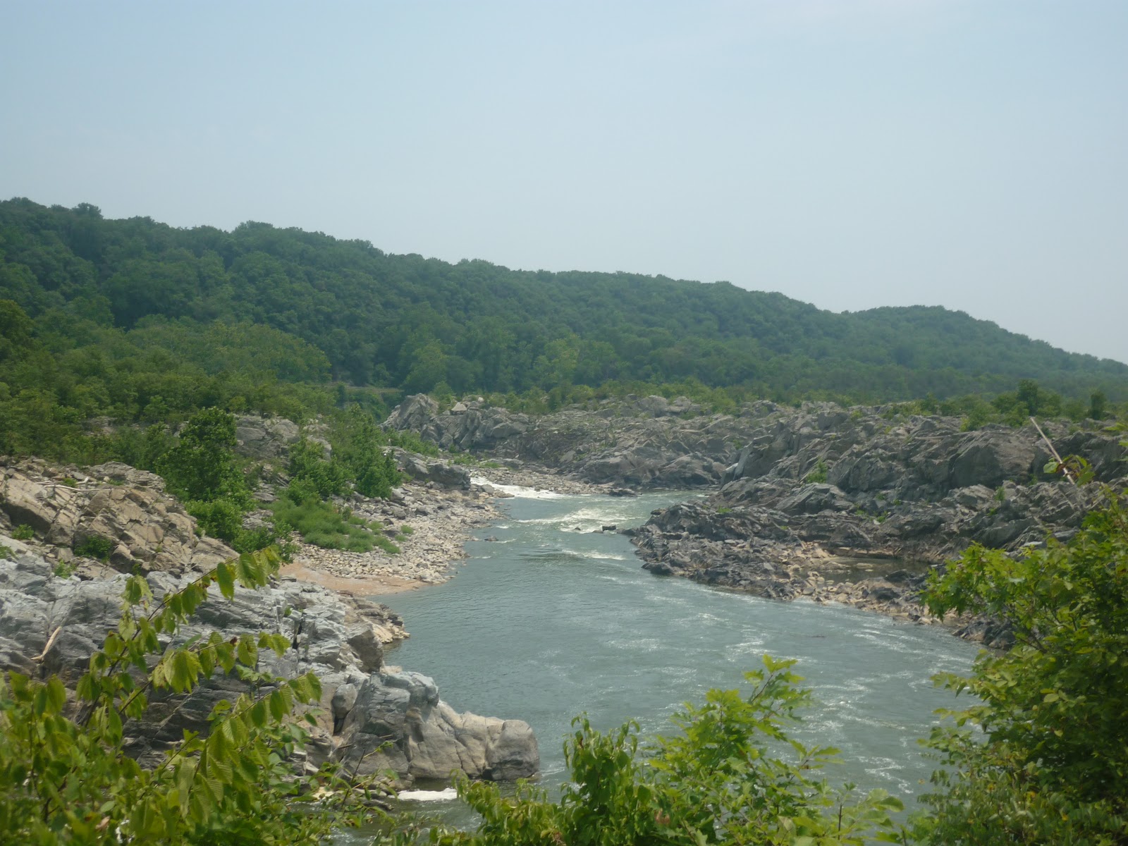
Even in the brutal heat of last summer, the place felt comfortable under the shade of the trees and with the mists coming off the river.
The Potomac retains this appearance for quite a while, until it winds down into a broad and level waterway in the capital proper. Even at the edge of the district, it still runs in a gorge and winds around massive rock formations. Take a look at how the river is off of Chain Bridge, one of the oldest and most heavily used bridge crossings on the length of the waterway.

Most people, residents and visitors alike, never make their way even this close upstream and assume the Potomac to be, like the Thames, Seine, Hudson, or Mississippi, yet another great river that forms a nice center piece to a city studded with monumental buildings and an impressive skyline. Iconic Washington, after all, consists of marble buildings built on reclaimed land and cultivated cherry blossom pleasure gardens. The capital was built for the needs of a young nation curious of a continent, but focused on human achievements and developed land. For George himself, the Potomac and other eastern rivers were arteries of commerce and calm tidal estuaries that led back to the sea. While he did find the falls lovely, he certainly loved the lower river more, and considered the view from his back porch to be his promised land.

The broad rivers of lower Virginia could certainly be admired. They were where the first Virginians settled and started building a new life for themselves off the shores of the broad James river.

The choice of landing was not unique to the forerunners of the Americans, either. The first European Canadians sailed up to bluffs overlooking the greatest estuary they had ever seen, and founded Quebec at the point where fresh and salt waters mixed. They would press up the St. Lawrence and later set the foundations for Montreal, like Washington, at the head of navigation. Later cities would be founded in gentle areas ripe for development and colonization at New York, Boston, Charleston, St. Louis, and far across the continent in San Diego and Los Angeles. Veracruz, the first city on mainland North America, would be founded in 1519 right on the Gulf of Mexico, easily accessible from other Spanish holdings in the Caribbean. Cortez, despite his rather bold and suicidal attack on Tenochtitlan, would keep his capital on the islands he conquered in Lake Texcoco. Mexico City, as it would be renamed, would be kept safe and within comfortable trading distance of the coast.
Yet history would remind us that the destiny of North America would rest not on easy shores or within great cities. Even as Veracruz, Jamestown, and Quebec were founded, their settlers would push inland. Mexicans would travel northwards into the great deserts and mountains, the Americans would always want to see what would be just beyond another ridge of those Appalachians, and Canadians could not resist the urge to take the canoe over yet another portage into the most wild and beautiful lands they could imagine. The peoples before them would move as well. In times very long ago, the Aztecs would come from the northern deserts, just as the Lakota would leave behind the forests of Minnesota and Ontario to dwell in the plains, and the Algonquins and Cree would perfect the art of canoe making and portage blazing well before any Frenchman would land on these shores. All of these people would find the rocky, upper reaches of rivers such as the Potomac (such as here, at Harper's Ferry) to be irresistible.


Here, the river breaks through the wall of the Appalachians in a rapid rush that at once both informs of more difficult terrain on the way, and invites those who can engage it to find out what is beyond the gap. Cottonwoods and Silver maples line the shores in a preview of thick, lovely forests beyond. North America is a land of fine harbors and fertile plains, but it is also a wild land to soothe the explorer's heart.
Subscribe to:
Posts (Atom)