
Now, not much is left of this unique area which lies between northeast, southeast, Carolinian piedmont, and appalachian forests. Much of it has been urbanized, and areas beyond the city limits have been heavily farmed since the colonial era. Some of the first preservation efforts in the eastern United States did happen here, however, and there are a number of lovely recreation-oriented nature parks in the region, such as Catoctin, Prince William forest park, and Rock Creek Park. There is one very special park, however.

Way back in 1790, George Washington was tasked with selecting an appropriate site for a new national capital. His heart was immediately drawn to the Potomac valley, where he had grown up, chosen to build himself a house, and saw a possible link between the Ohio Valley and the eastern seaboard in the gap the river created in passing through the Appalachians. Fortunately, Thomas Jefferson and James Madison wanted the new capital to be located somewhere in the southern states, and Alexander Hamilton strongly desired fiscal solvency. In what I can only imagine to be a rather humorous parlor scene, Jefferson and Madison most likely smiled at each other and told Hamilton they would back him up and let the Federal government assume the war debt if he would get his people to agree that the capital should be in the southern states.
So why the Potomac, and why here? Well, the capital would need to have ocean access, no doubt about it. At the same time, the capital would need a degree of protection from seaborne assault, and would be best situated somewhere as a hub of national travel, not too far from the extreme points of the new nation. Congress knew the Potomac could fulfill these criteria, and Washington was told to select the site. In his younger years, he had often traveled to these falls. He considered them beautiful, but also quite the obstacle. He dreamed of a canal overcoming the navigation head that the falls were, and figured that the most suitable place for the new capital would be just downstream from them, across from an existing port town at Georgetown.

The southern delegates got the capital landed in between two slave states, and the northern delegates ended up getting a capital within good communicable distance of Philadelphia and New York (orange and pink dots). Washington's canal dream would come true in 1831, though by that time it would be largely eclipsed in trade by the Erie Canal (dark blue). In terms of general human migration, his canal (light blue) would play second string to both the nearby National Road and the Cumberland Gap (light green, actual gap being yellow) farther south. All of these old routes can still be traversed and seen today in various parks, national scenic trails, and modern highways. The Appalachians may not be as significant a wall as the Rockies, but then, and even now, they are enough of a wall that people would pass through them only in specific spots.
Nature, of course, is no less dramatic. The Potomac, like the Susquehanna, Delaware, Hudson, and numerous other eastern rivers cut through the wall in rather lovely falls, gorges, and otherwise scenic, rocky affairs. Each of these great gates to the lands beyond the eastern shores would impress early industrialists with the power of nature, and spur the later development of hydroelectric resources.


For all the inspiration they provided to industry and development, however, places like these Great Falls of the Potomac and the Delaware Water Gap would remain somewhat pristine, admired for their natural beauty. Even though the falls are largely surrounded by urban development, and only miles away from downtown Washington, they sit in a heavily wooded area that leaves an impression of wilderness rather than civilization.
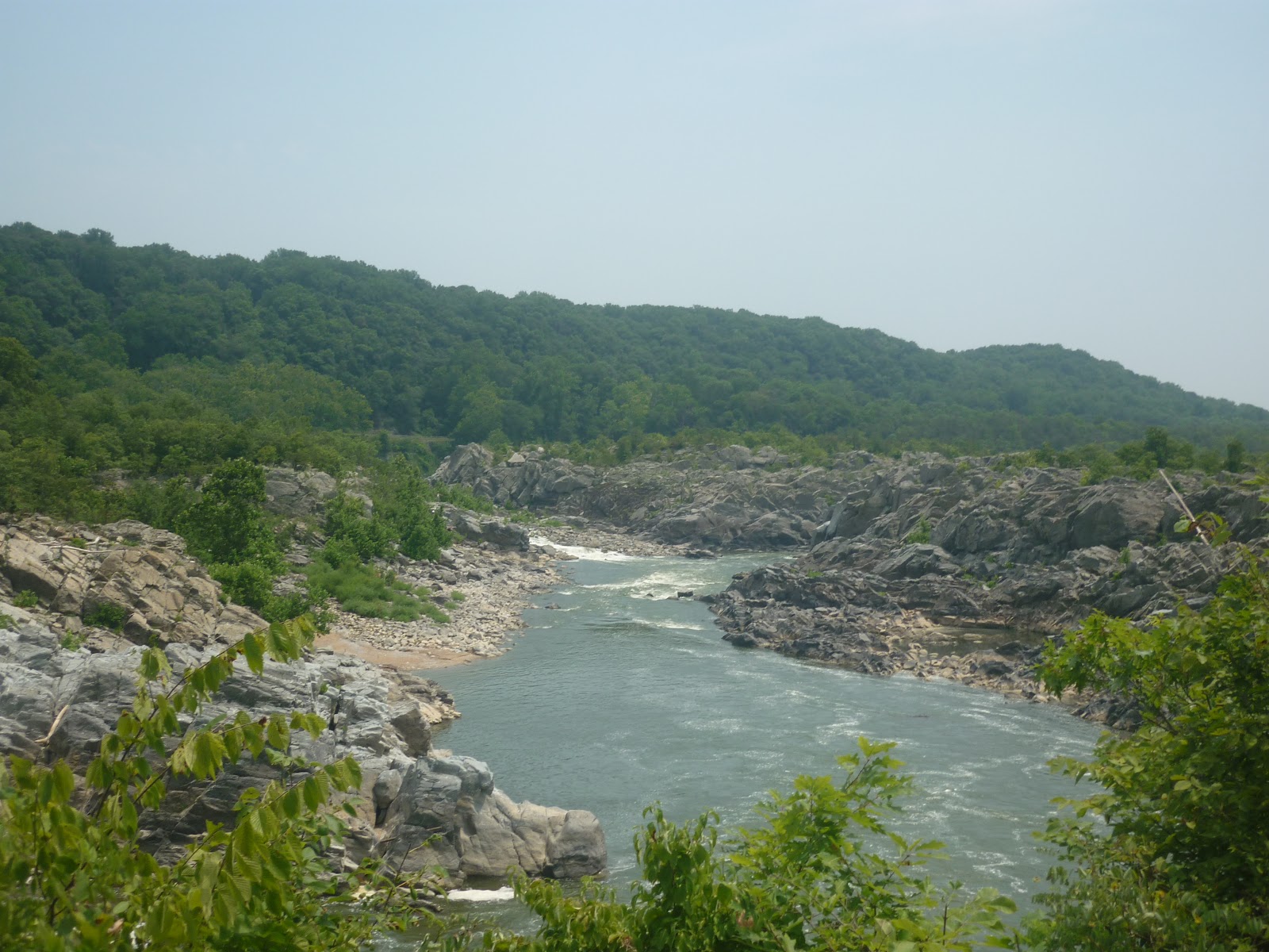
Even in the brutal heat of last summer, the place felt comfortable under the shade of the trees and with the mists coming off the river.
The Potomac retains this appearance for quite a while, until it winds down into a broad and level waterway in the capital proper. Even at the edge of the district, it still runs in a gorge and winds around massive rock formations. Take a look at how the river is off of Chain Bridge, one of the oldest and most heavily used bridge crossings on the length of the waterway.

Most people, residents and visitors alike, never make their way even this close upstream and assume the Potomac to be, like the Thames, Seine, Hudson, or Mississippi, yet another great river that forms a nice center piece to a city studded with monumental buildings and an impressive skyline. Iconic Washington, after all, consists of marble buildings built on reclaimed land and cultivated cherry blossom pleasure gardens. The capital was built for the needs of a young nation curious of a continent, but focused on human achievements and developed land. For George himself, the Potomac and other eastern rivers were arteries of commerce and calm tidal estuaries that led back to the sea. While he did find the falls lovely, he certainly loved the lower river more, and considered the view from his back porch to be his promised land.

The broad rivers of lower Virginia could certainly be admired. They were where the first Virginians settled and started building a new life for themselves off the shores of the broad James river.

The choice of landing was not unique to the forerunners of the Americans, either. The first European Canadians sailed up to bluffs overlooking the greatest estuary they had ever seen, and founded Quebec at the point where fresh and salt waters mixed. They would press up the St. Lawrence and later set the foundations for Montreal, like Washington, at the head of navigation. Later cities would be founded in gentle areas ripe for development and colonization at New York, Boston, Charleston, St. Louis, and far across the continent in San Diego and Los Angeles. Veracruz, the first city on mainland North America, would be founded in 1519 right on the Gulf of Mexico, easily accessible from other Spanish holdings in the Caribbean. Cortez, despite his rather bold and suicidal attack on Tenochtitlan, would keep his capital on the islands he conquered in Lake Texcoco. Mexico City, as it would be renamed, would be kept safe and within comfortable trading distance of the coast.
Yet history would remind us that the destiny of North America would rest not on easy shores or within great cities. Even as Veracruz, Jamestown, and Quebec were founded, their settlers would push inland. Mexicans would travel northwards into the great deserts and mountains, the Americans would always want to see what would be just beyond another ridge of those Appalachians, and Canadians could not resist the urge to take the canoe over yet another portage into the most wild and beautiful lands they could imagine. The peoples before them would move as well. In times very long ago, the Aztecs would come from the northern deserts, just as the Lakota would leave behind the forests of Minnesota and Ontario to dwell in the plains, and the Algonquins and Cree would perfect the art of canoe making and portage blazing well before any Frenchman would land on these shores. All of these people would find the rocky, upper reaches of rivers such as the Potomac (such as here, at Harper's Ferry) to be irresistible.


Here, the river breaks through the wall of the Appalachians in a rapid rush that at once both informs of more difficult terrain on the way, and invites those who can engage it to find out what is beyond the gap. Cottonwoods and Silver maples line the shores in a preview of thick, lovely forests beyond. North America is a land of fine harbors and fertile plains, but it is also a wild land to soothe the explorer's heart.
No comments:
Post a Comment